Latitude: 51.5263 / 51°31'34"N
Longitude: -2.3071 / 2°18'25"W
OS Eastings: 378789
OS Northings: 180870
OS Grid: ST787808
Mapcode National: GBR 0NT.CHP
Mapcode Global: VH95V.YWPS
Plus Code: 9C3VGMGV+G5
Entry Name: Range of Barns About 4 Metres West of Newhouse Farmhouse
Listing Date: 17 September 1952
Grade: II
Source: Historic England
Source ID: 1213201
English Heritage Legacy ID: 397659
ID on this website: 101213201
Location: South Gloucestershire, GL9
County: South Gloucestershire
Civil Parish: Tormarton
Traditional County: Gloucestershire
Lieutenancy Area (Ceremonial County): Gloucestershire
Church of England Parish: Tormarton with West Littleton
Church of England Diocese: Bristol
Tagged with: Barn
ST 78 SE TORMARTON C.P. -
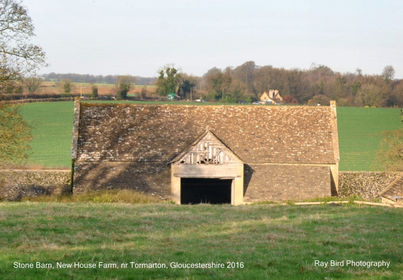
3/226 Range of barns about 4 metres west
17.9.52 of Newhouse Farmhouse
G.V.
II
2 attached barns and attached open-fronted shelter shed. Late C18 with later
alterations. Rubble with stone dressings, stone slate roofs with raised coped
verges, kneelers and finials. South barn has south elevation with high gabled
cart entry and lean-to at each side continuing slope of main roof, right return
has 4-pane window in gable end and stepped stonework under verges; rear has cart
entry with heavy cambered timber lintel and half-hipped roof, lean-to to left as
on front. Lower barn attached to right has blocked window, cart entry to eaves
height, C20 addition in corrugated iron, external stair in blue brick to right,
loading door, 2 ventilation slits, lower door and 4-pane light; north elevation
has door and 2-light casement in gable end with chamfered stone mullion. L-plan
shelter shed attached to west, 7 bays with timber piers supporting eaves, bay to
west closed with doors, tie-beam roof with 2 struts, principal rafters and 2 rows
of purlins. Interior of barns not accessible.
Listing NGR: ST7878980870
External links are from the relevant listing authority and, where applicable, Wikidata. Wikidata IDs may be related buildings as well as this specific building. If you want to add or update a link, you will need to do so by editing the Wikidata entry.


Other nearby listed buildings