Latitude: 54.0492 / 54°2'57"N
Longitude: -2.8027 / 2°48'9"W
OS Eastings: 347540
OS Northings: 461770
OS Grid: SD475617
Mapcode National: GBR 8PWM.06
Mapcode Global: WH846.XHK4
Plus Code: 9C6V25XW+MW
Entry Name: 26 and 28, Sun Street
Listing Date: 13 March 1995
Grade: II
Source: Historic England
Source ID: 1214479
English Heritage Legacy ID: 383339
ID on this website: 101214479
Location: Lancaster, Lancashire, LA1
County: Lancashire
District: Lancaster
Electoral Ward/Division: Castle
Parish: Non Civil Parish
Built-Up Area: Lancaster
Traditional County: Lancashire
Lieutenancy Area (Ceremonial County): Lancashire
Church of England Parish: Lancaster St Mary with St John and St Anne
Church of England Diocese: Blackburn
Tagged with: Building
LANCASTER
SD4761NE SUN STREET 1685-1/7/306 (West side) Nos.26 AND 28
GV II
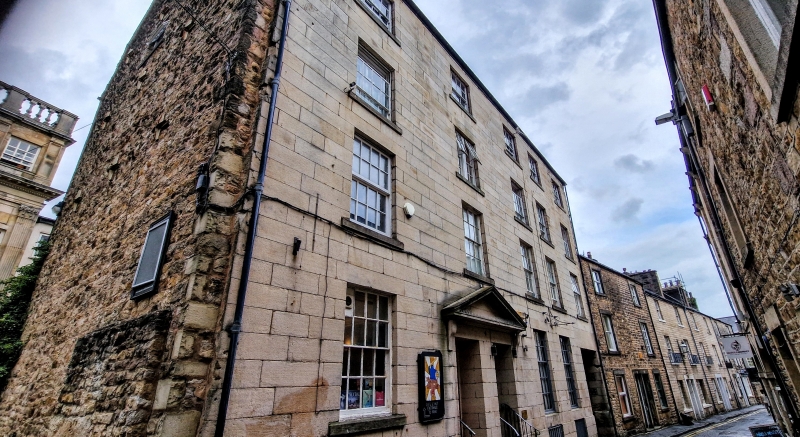
Pair of houses, now shops. c1800, altered C20. Sandstone ashlar, with coursed rubble to sides and rear. Slate roofs, and gable chimneys. Double-depth plan, with linked entrances in the second bay and short linked rear extensions, and a waggon entrance in the fifth bay, which to the left has what appears to be the remains of a loading bay and cellar entrance. 4 storeys above cellars, and 5 bays. All the openings have plain reveals. The doorways are slightly recessed under a wide pediment carried on 2 plain consoles and have 2 external steps and 3 recessed steps. The doors have 9 raised and fielded panels. The windows are sashed with glazing bars and have 20, 16 and 12 panes. Below all the ground-floor windows are low cellar openings. The waggon entrance has a flat lintel.
Listing NGR: SD4754061770
External links are from the relevant listing authority and, where applicable, Wikidata. Wikidata IDs may be related buildings as well as this specific building. If you want to add or update a link, you will need to do so by editing the Wikidata entry.


Other nearby listed buildings