Latitude: 54.0493 / 54°2'57"N
Longitude: -2.8025 / 2°48'8"W
OS Eastings: 347556
OS Northings: 461777
OS Grid: SD475617
Mapcode National: GBR 8PWM.26
Mapcode Global: WH846.XHN3
Plus Code: 9C6V25XX+P2
Entry Name: 25, Sun Street
Listing Date: 13 March 1995
Grade: II
Source: Historic England
Source ID: 1195057
English Heritage Legacy ID: 383338
ID on this website: 101195057
Location: Lancaster, Lancashire, LA1
County: Lancashire
District: Lancaster
Electoral Ward/Division: Castle
Parish: Non Civil Parish
Built-Up Area: Lancaster
Traditional County: Lancashire
Lieutenancy Area (Ceremonial County): Lancashire
Church of England Parish: Lancaster St Mary with St John and St Anne
Church of England Diocese: Blackburn
Tagged with: Building
LANCASTER
SD4761NE SUN STREET 1685-1/7/305 (East side) No.25
GV II
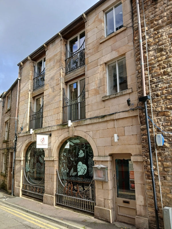
Coach house, now part of printing works. Late C18, altered early C19 and C20. Sandstone ashlar, with coursed rubble to sides and rear, and slate roof. Double-depth plan with gable chimney stacks, and a rear extension to the left. 3 storeys and 3 bays, 2 wide ones with a narrow one to the right. A band between the ground and first floors and stone gutter-brackets. The ground floor is composed of 2 arched openings, now blocked and partly glazed, whose imposts form a broken band and whose keystones rise to meet the band above the ground floor. To the right is a narrow doorway, now with a glazed door; the lower face of its lintel is hollowed to give the appearance of a basket arch. All the windows have plain reveals but recent joinery. Those above the arches have concrete lintels. Masonry infill between the windows to the 2 upper windows in the left-hand bay suggests that there may have been a loading slot here. INTERIOR: ground floor originally open, with a staircase to the first floor across the back wall. HISTORY: marked on the 5 feet to one mile OS map, surveyed in 1845, as a police station, although built as a coach house on the ground floor. (Ordnance Survey: Map of Lancaster at Five Feet to One Mile: Southampton: 1849-).
Listing NGR: SD4757161789
External links are from the relevant listing authority and, where applicable, Wikidata. Wikidata IDs may be related buildings as well as this specific building. If you want to add or update a link, you will need to do so by editing the Wikidata entry.


Other nearby listed buildings