Approximate Location Map
Large Map »
Latitude: 52.4767 / 52°28'36"N
Longitude: -0.2503 / 0°15'1"W
OS Eastings: 518932
OS Northings: 287968
OS Grid: TL189879
Mapcode National: GBR J0V.PK5
Mapcode Global: VHGL8.M01P
Plus Code: 9C4XFPGX+MV
Entry Name: Parish Church of St Giles
Listing Date: 13 December 1957
Grade: II*
Source: Historic England
Source ID: 1215533
English Heritage Legacy ID: 400787
ID on this website: 101215533
Location: St Giles's Church, Holme, Huntingdonshire, Cambridgeshire, PE7
County: Cambridgeshire
District: Huntingdonshire
Civil Parish: Holme
Built-Up Area: Holme
Traditional County: Huntingdonshire
Lieutenancy Area (Ceremonial County): Cambridgeshire
Church of England Parish: Holme St Giles
Church of England Diocese: Ely
Tagged with: Church building
HOLME CHURCH STREET
TL 1887
(North Side)
12/34 Parish church of St
Giles
13.12.57
GV II*
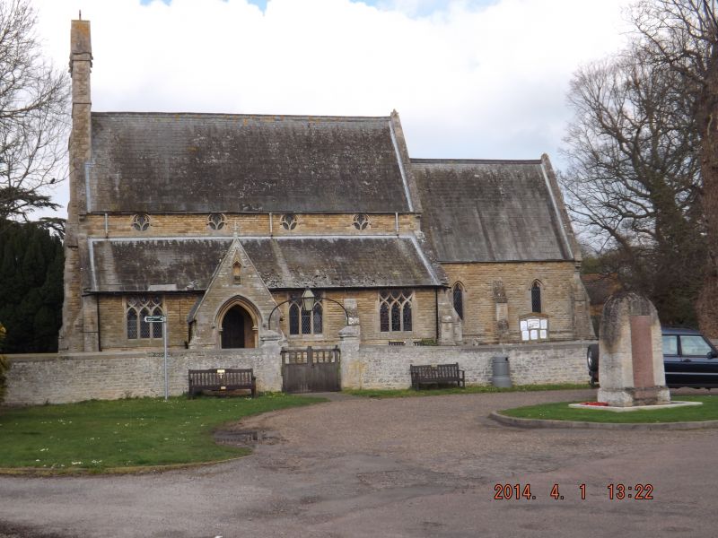
Parish Church. Reused C12 and C13 material from original parish church
demolished and rebuilt in 1862 by Edward Browning. Hammer dressed limestone
walls; plain tiled roofs with parapet gables. South elevation: bellcote to
west end with double linked gables with two bells. Four clerestory windows
with tracery and south aisle windows with square-headed arches and tracery in
Decorated style. South porch and doorway incorporating early material in
jambs of two-centred arches. Two chancel windows of two lancet-lights with
stopped labels. Interior: nave arcades of three bays extended by one bay to
west incorporating the original two-centred arches supported on octagonal and
circular columns with moulded and cushion capitals and moulded bases.
Two-centred chancel arch of two chamfered orders springing from moulded
corbels; organ chamber with two-centred archway on north side of chancel.
Font, plain octagonal bowl recorded in 1851 (VCH). For monuments and wall
plaques see (VCH).
V C H Huntingdonshire, p187
R C H M Huntingdonshire, p140
Pevsner: Buildings of England, p266
Glatton, Holme and Denton, estate map for Wm Wells 1770 H.R.O.
Listing NGR: TL1893287968
External links are from the relevant listing authority and, where applicable, Wikidata. Wikidata IDs may be related buildings as well as this specific building. If you want to add or update a link, you will need to do so by editing the Wikidata entry.


Other nearby listed buildings
