Approximate Location Map
Large Map »
Latitude: 52.123 / 52°7'22"N
Longitude: -1.3571 / 1°21'25"W
OS Eastings: 444112
OS Northings: 247383
OS Grid: SP441473
Mapcode National: GBR 7S0.ZMW
Mapcode Global: VHCVV.FWFW
Plus Code: 9C4W4JFV+65
Entry Name: The Jetty
Listing Date: 26 February 1988
Grade: II
Source: Historic England
Source ID: 1216576
English Heritage Legacy ID: 402009
ID on this website: 101216576
Location: Mollington, Cherwell, Oxfordshire, OX17
County: Oxfordshire
District: Cherwell
Civil Parish: Mollington
Built-Up Area: Mollington
Traditional County: Oxfordshire
Lieutenancy Area (Ceremonial County): Oxfordshire
Church of England Parish: Mollington
Church of England Diocese: Oxford
Tagged with: Architectural structure Thatched cottage
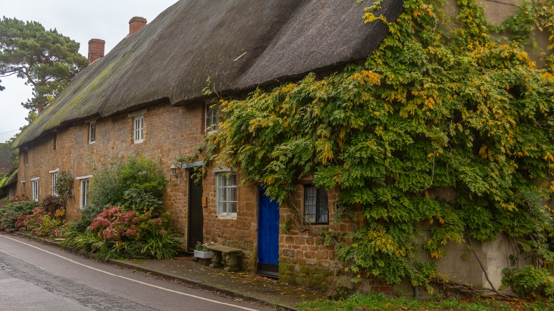
MOLLINGTON MAIN STREET
SP4447 (South side)
13/143 Nos.5, 6, 7/8, 9/10 (The
Jetty)
GV II
Shown as Nos.5, 6, 7, 8, 9 and 10 The Jitty on the Ordnance Survey map.
House, now 4 dwellings. C17 altered C18 and C19. Squared coursed lias with
thatch roof. Originally probably 4-unit plan. 2 storeys. Together comprising an
irregular 6-window range of C19 and C20 casements under wood lintels. 2 window,
to first floor right, have old leaded casements. C20 door, to right, is also
under wood lintel. 6 brick stacks at ridge and ends. One-unit single storey
extension, to left, also has thatch roof. Right gable is rendered. Rear
elevation is similar with C19 and C20 doors under wood lintels and C20 porch to
right. Interior: Nos.7/8 and 9/10 have open fireplaces with bressumers. Room to
right of No.9/10 probably formed hall of original house with adjacent room of
No.7/8. Stopped-chamfered spine beams and rafters and chamfered wall beams. Some
original roof structure is visible in No.9/10. Probably subdivided to form
farmworkers houses C18 or C19.
Listing NGR: SP4411247383
External links are from the relevant listing authority and, where applicable, Wikidata. Wikidata IDs may be related buildings as well as this specific building. If you want to add or update a link, you will need to do so by editing the Wikidata entry.


Other nearby listed buildings
