Approximate Location Map
Large Map »
Latitude: 51.3512 / 51°21'4"N
Longitude: 0.3195 / 0°19'10"E
OS Eastings: 561614
OS Northings: 163901
OS Grid: TQ616639
Mapcode National: GBR Z1.M71
Mapcode Global: VHHPG.H97H
Plus Code: 9F329829+FQ
Entry Name: Church of Saint Peter
Listing Date: 1 June 1967
Grade: II*
Source: Historic England
Source ID: 1216987
English Heritage Legacy ID: 411280
ID on this website: 101216987
Location: St Peter's Church, Ridley, Sevenoaks, Kent, TN15
County: Kent
District: Sevenoaks
Civil Parish: Ash-cum-Ridley
Traditional County: Kent
Lieutenancy Area (Ceremonial County): Kent
Church of England Parish: Ridley St Peter
Church of England Diocese: Rochester
Tagged with: Church building
ASH-CUM-RIDLEY RECTORY ROAD
1.
5280
Ridley
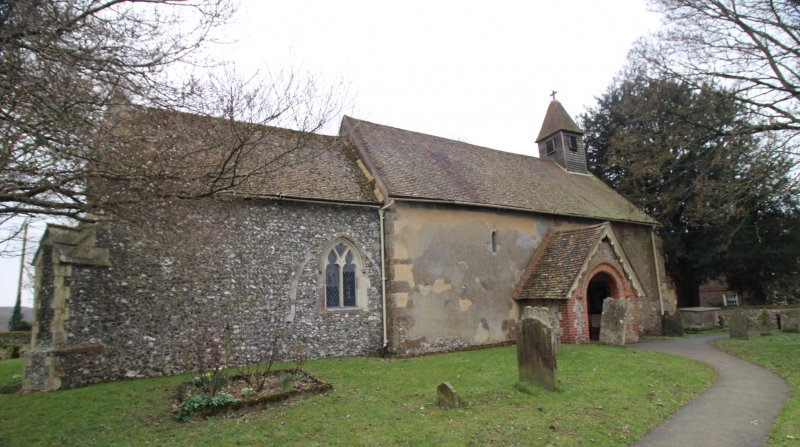
Church of St Peter
TQ 66 SV 7/21 1.6.67
II* GV
2.
Nave Norman, C13 chancel, renewed in C19 and C19 porch. Built of flint (the
Nave now cemented) with weatherboarded bell cote of circa 1797. C19 font and
C18 wooden lectern.
Listing NGR: TQ6161864162
External links are from the relevant listing authority and, where applicable, Wikidata. Wikidata IDs may be related buildings as well as this specific building. If you want to add or update a link, you will need to do so by editing the Wikidata entry.


Other nearby listed buildings
