Approximate Location Map
Large Map »
Latitude: 51 / 51°0'0"N
Longitude: -0.8493 / 0°50'57"W
OS Eastings: 480840
OS Northings: 122922
OS Grid: SU808229
Mapcode National: GBR CCF.83H
Mapcode Global: FRA 963G.NY6
Plus Code: 9C3X2522+27
Entry Name: Habin Bridge
Listing Date: 18 June 1959
Grade: II
Source: Historic England
Source ID: 1217003
English Heritage Legacy ID: 411734
ID on this website: 101217003
Location: Habin, Chichester, West Sussex, GU31
County: West Sussex
District: Chichester
Civil Parish: Rogate
Traditional County: Sussex
Lieutenancy Area (Ceremonial County): West Sussex
Church of England Parish: Rogate St Bartholomew with Terwick St Peter
Church of England Diocese: Chichester
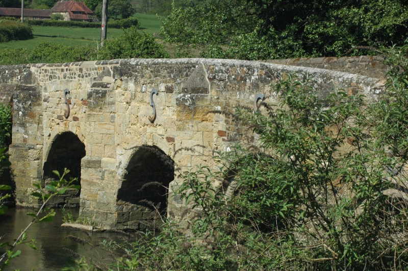
ROGATE HABIN ROAD
SU 8023, 8123
10/33 Habin Bridge
18.6.59
- II
Bridge. C17 or earlier, restored in the C18. Hythe sandstone. Four round-headed arches, ribbed on the south side. The north two have chamfered key blocks. Five V-
shaped cutwaters on west side, three rectangular ones on east side. Scheduled
Ancient Monument.
Listing NGR: SU8084022922
External links are from the relevant listing authority and, where applicable, Wikidata. Wikidata IDs may be related buildings as well as this specific building. If you want to add or update a link, you will need to do so by editing the Wikidata entry.


Other nearby listed buildings
