Latitude: 53.3967 / 53°23'48"N
Longitude: -3.0659 / 3°3'57"W
OS Eastings: 329219
OS Northings: 389402
OS Grid: SJ292894
Mapcode National: GBR 7Y15.13
Mapcode Global: WH761.WW6D
Plus Code: 9C5R9WWM+MJ
Entry Name: Main Western Gates to Flaybrick Hill Cemetery Adjacent to the Cemetery Chapels
Listing Date: 28 March 1974
Last Amended: 10 August 1992
Grade: II
Source: Historic England
Source ID: 1217805
English Heritage Legacy ID: 389131
ID on this website: 101217805
Location: Flaybrick Memorial Gardens, Bidston, Wirral, Merseyside, CH43
County: Wirral
Electoral Ward/Division: Bidston and St James
Parish: Non Civil Parish
Traditional County: Cheshire
Lieutenancy Area (Ceremonial County): Merseyside
Church of England Parish: Bidston St Oswald
Church of England Diocese: Chester
Tagged with: Gate Architectural structure Gatepost
This list entry was subject to a Minor Amendment on 11/11/2014
SJ28NE
789-1/3/30
BIRKENHEAD
BOUNDARY ROAD (East side)
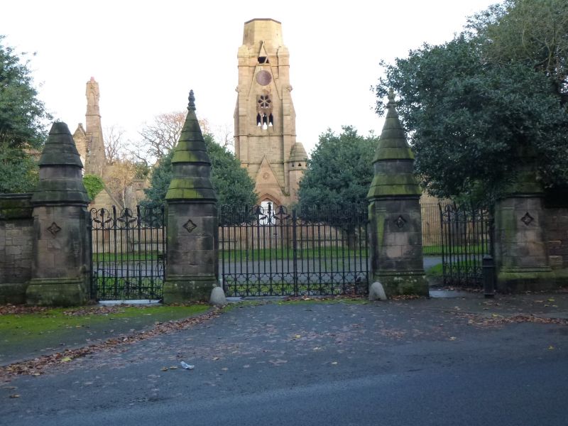
Main western gates to Flaybrick Hill Cemetery adjacent to the cemetery chapels.
(Formerly listed as Southern Gates to Flaybrick Hill Cemetery, previously listed as Southern entrance gateway to Flaybrick Hill Cemetery)
28/03/74
GV
II
Entrance gates to Flaybrick Hill Cemetery.1864. By Lucy and Littler. Stone gate piers and cast-iron gates. Gate piers to main and side gates in flanking wall with chamfered plinth and raking coping. Polygonal gate piers with stepped tapered caps with finials. Incised quatrefoil decoration incorporating date and initials BIC (Birkenhead Improvement Commissioners). Cast-iron gates have twisted shafts with arrow heads and scroll-work.
For the other principal cemetery buildings see under Tollemache Road.
The Buildings of England: Nikolaus Pevsner and Edward
Hubbard: Cheshire: Harmondsworth: 1971.
Listing NGR: SJ2921989402
External links are from the relevant listing authority and, where applicable, Wikidata. Wikidata IDs may be related buildings as well as this specific building. If you want to add or update a link, you will need to do so by editing the Wikidata entry.


Other nearby listed buildings