Latitude: 50.3508 / 50°21'2"N
Longitude: -3.5825 / 3°34'57"W
OS Eastings: 287508
OS Northings: 51296
OS Grid: SX875512
Mapcode National: GBR QS.R97N
Mapcode Global: FRA 38D3.L4Q
Plus Code: 9C2R9C28+8X
Entry Name: The Guildhall and Attached Boundary Wall to West
Listing Date: 23 October 1972
Last Amended: 23 February 1994
Grade: II
Source: Historic England
Source ID: 1218299
English Heritage Legacy ID: 387398
ID on this website: 101218299
Location: Dartmouth, South Hams, Devon, TQ6
County: Devon
District: South Hams
Civil Parish: Dartmouth
Built-Up Area: Dartmouth
Traditional County: Devon
Lieutenancy Area (Ceremonial County): Devon
Church of England Parish: Dartmouth Townstal
Church of England Diocese: Exeter
Tagged with: Building
DARTMOUTH
SX874510 VICTORIA ROAD 673-1/8/281 (South side) 23/10/72 The Guildhall and attached boundary wall to west (Formerly Listed as: VICTORIA ROAD (South side) Guildhall)
GV II
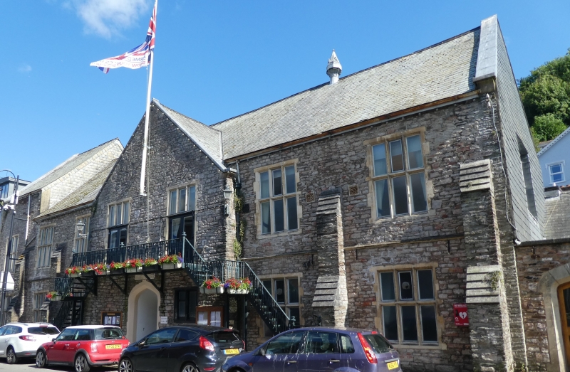
Guildhall, now municipal offices, originally subscription rooms and school. Dated 1849. Local limestone rubble with Bathstone dressings; slate roof. EXTERIOR: Restrained Tudor style. 2 storeys. Main block has symmetrical 2:2:2-window front with an extra bay to left in taller block; all stone 3-light mullion-and-transom windows, now containing plate glass. Centre 2-window section breaks forward slightly to contain large central Tudor-arch doorway, with the date of 1849 carved onto a plaque directly above. First-floor windows now converted to doorways with upper lights retained as mullioned overlights, and secondary balcony shelters main doorway below. Gable over. Balcony and steps both sides have ornate cast-iron railings. String course at first-floor level interrupted by 2 large weathered buttresses each side. Main roof is gable-ended and steps up to a higher level over left end bay. Front and end gables with shaped kneelers and coping and 2 ventilators with small spires projecting through the ridge of the main block. Right end contains a first-floor 4-light window similar to those on the front. INTERIOR: Not inspected. SUBSIDIARY FEATURES: A tall stone boundary wall extends westward from the right-hand end and includes a stone Tudor-arched doorway. This building is one of a good group of buildings dating from the second quarter of the C19 lining New Road (now Victoria Road), which was built in 1825 to enable, for the first time, horse-drawn carriages in and out of town.
Listing NGR: SX8750851296
External links are from the relevant listing authority and, where applicable, Wikidata. Wikidata IDs may be related buildings as well as this specific building. If you want to add or update a link, you will need to do so by editing the Wikidata entry.


Other nearby listed buildings