Latitude: 53.7432 / 53°44'35"N
Longitude: -2.9893 / 2°59'21"W
OS Eastings: 334852
OS Northings: 427880
OS Grid: SD348278
Mapcode National: GBR 7TK4.MW
Mapcode Global: WH85P.15TQ
Plus Code: 9C5VP2V6+77
Entry Name: Church Farm and Garden Wall
Listing Date: 15 February 1993
Grade: II
Source: Historic England
Source ID: 1218813
English Heritage Legacy ID: 385265
ID on this website: 101218813
Location: Ansdell, Fylde, Lancashire, FY8
County: Lancashire
District: Fylde
Electoral Ward/Division: Ansdell
Parish: Ansdell
Built-Up Area: Lytham St Anne's
Traditional County: Lancashire
Lieutenancy Area (Ceremonial County): Lancashire
Church of England Parish: Ansdell and Fairhaven St Paul
Church of England Diocese: Blackburn
Tagged with: Architectural structure
LYTHAM ST ANNES
SD32NW COMMONSIDE, Ansdell 621-1/2/2 (North side) No.23 Church Farm and garden wall
II
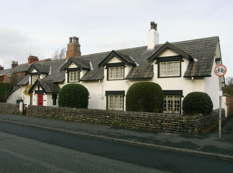
Farmhouse, now house. Late C17 or very early C18, remodelled in mid C19 and recently renovated. White-painted render on cobble, graduated slate roof. Single-depth linear 3-unit plan (plus 4th added in C20), with C19 rear wing. Formerly a 3-unit baffle-entry plan with open housepart in centre and lofted end bays. Jacobean style (typical of Clifton estate building in this area in C19). One-and-a-half storeys, now a 4-window range, with a low single-storey gabled porch between the 1st and 2nd bays (in line with the ridge chimney). This has a board door, a rectangular lintel with a label, a roof with projecting verges, and small windows in the side walls. The 4 windows at ground floor and 4 dormer windows above are all 3-light horizontal sliding sashes with small panes and labels over, and the dormers have projecting verges. Square 4-flue chimney on ridge in line with porch, lateral 2-flue chimney at the junction with the added 4th bay, and tall single-flue chimney at left gable. Single-storey C19 service wing to rear. INTERIOR: original plan altered by insertion of ceiling and removal of inglenook leaving only the heck; 2 axial beams in 3rd bay, both chamfered and one with a C17 stop; roof truss between 2nd and 3rd bays with severed tie-beam; and, in 3rd bay close to this, remains of a staircase partition wall of hand-made brick at ground floor and clamstaff-and-daub above (altered staircase). Front garden enclosed by garden wall of cobble.
Listing NGR: SD3485227880
External links are from the relevant listing authority and, where applicable, Wikidata. Wikidata IDs may be related buildings as well as this specific building. If you want to add or update a link, you will need to do so by editing the Wikidata entry.


Other nearby listed buildings