Latitude: 53.7386 / 53°44'19"N
Longitude: -2.9902 / 2°59'24"W
OS Eastings: 334782
OS Northings: 427370
OS Grid: SD347273
Mapcode National: GBR 7TK6.FK
Mapcode Global: WH85P.19C7
Plus Code: 9C5VP2Q5+CW
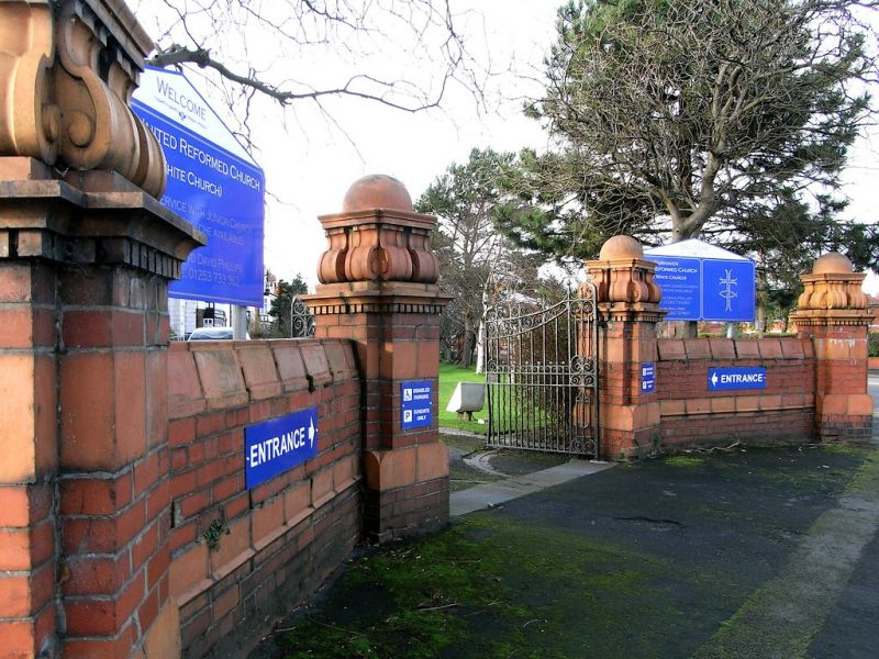
Entry Name: Gate Piers and Boundary Wall to Grounds of Fairhaven United Reformed Church
Listing Date: 15 February 1993
Grade: II
Source: Historic England
Source ID: 1297686
English Heritage Legacy ID: 385260
ID on this website: 101297686
Location: The White Church, Fairhaven, Fylde, Lancashire, FY8
County: Lancashire
District: Fylde
Electoral Ward/Division: Ansdell
Parish: Ansdell
Built-Up Area: Lytham St Anne's
Traditional County: Lancashire
Lieutenancy Area (Ceremonial County): Lancashire
Church of England Parish: Ansdell and Fairhaven St Paul
Church of England Diocese: Blackburn
Tagged with: Gatepost
LYTHAM ST ANNES
SD32NW CLIFTON DRIVE SOUTH, Fairhaven 621-1/2/7 (South West side) Gate piers and boundary wall to grounds of Fairhaven United Reformed Church
GV II
Gate piers and boundary wall. Probably c.1904. Red brick with dressings of buff terracotta. Forms boundary to front facing Clifton Drive and returned side facing Ansdell Road South, with the main gateway in a concave quadrant at the corner and secondary gateways at the outer ends of both sides. Low brick walls with pitched coping of terracotta and regularly spaced brick piers with terracotta tops; at the corner, 4 large square piers in Baroque style, with chamfered corners, terracotta bands, dentilled cornices and paired console supporters to domed caps. Forms group with associated Fairhaven United Reformed Church.
Listing NGR: SD3478227370
External links are from the relevant listing authority and, where applicable, Wikidata. Wikidata IDs may be related buildings as well as this specific building. If you want to add or update a link, you will need to do so by editing the Wikidata entry.


Other nearby listed buildings