Latitude: 51.4476 / 51°26'51"N
Longitude: 0.0482 / 0°2'53"E
OS Eastings: 542428
OS Northings: 174058
OS Grid: TQ424740
Mapcode National: GBR MS.JV2
Mapcode Global: VHHNQ.SWB4
Plus Code: 9F32C2XX+27
Entry Name: Walls of Inner Courtyard to Eltham Palace, with Chambers Adjoining
Listing Date: 8 June 1973
Grade: I
Source: Historic England
Source ID: 1218900
English Heritage Legacy ID: 200289
ID on this website: 101218900
Location: Eltham, Greenwich, London, SE9
County: London
District: Greenwich
Electoral Ward/Division: Eltham South
Parish: Non Civil Parish
Built-Up Area: Greenwich
Traditional County: Kent
Lieutenancy Area (Ceremonial County): Greater London
Church of England Parish: Eltham St John the Baptist
Church of England Diocese: Southwark
Tagged with: Wall
1. 4412 COURT YARD SE9 (South end)
Walls of inner courtyard to Eltham Palace, with chambers adjoining TQ 4274 53/W33A TQ 4273 59/W33A
I
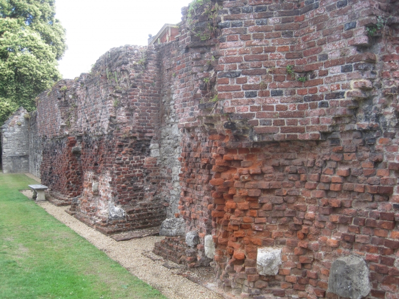
2. Palace founded by Bishop Antony Bec of Durham, circa 1300 but most of visible building now seems to be of late C15 or C16. Red brick walls on stone foundations of varying heights form a rough quadrangle around the Great Hall. The lower walls of a series of chambers built against the West Wall have recently been excavated. These are of roughly dressed stone, with smaller rubble filling, and rest on stone foundations. Some brick walling remains above. Part of floor of North-West room remains, sloping to a central gutter. A vaulted, drain- like passage runs west from well to wall above moat. Part of foundations of chapel exposed just South of well. Another passage, with 4-centred arched entrance, runs in from South-East angle. Inner North wall, of red brick, has small openings with gauged brick round arches. A short piece of wall, with 2 4-centred arches, runs south from South-east angle of bridge. From outside the walls are much higher, with 20 or 25 ft of stone foundation running down to moat, and about 8 ft of brick wall above, some of which is defined by pilasters, plinth and coping, forming sunk panels. Towers at angles at South-east a small square turret, largely brick; at north-east a small, square tower; at north-west a large, square projecting angle tower; and at south-west 5 brick turrets or large buttresses-with distinct diaper of blue headers. Also along West Wall a range of brick towers coming much lower on the stone foundation than the other walls. Passages, possibly drains, run out from these towers. A pair of squarer stone towers, with brick upper parts, about half way along West wall. Running out from South-west corner a tall passage or drain with ventilation holes. Brick buttress with diaper pattern to east of its issue.
Listing NGR: TQ4242874058
External links are from the relevant listing authority and, where applicable, Wikidata. Wikidata IDs may be related buildings as well as this specific building. If you want to add or update a link, you will need to do so by editing the Wikidata entry.


Other nearby listed buildings