Approximate Location Map
Large Map »
Latitude: 53.4698 / 53°28'11"N
Longitude: -2.2391 / 2°14'20"W
OS Eastings: 384222
OS Northings: 397028
OS Grid: SJ842970
Mapcode National: GBR DKM.V5
Mapcode Global: WHB9N.K1YV
Plus Code: 9C5VFQ96+W8
Entry Name: Ormond Building, Manchester Metropolitan University (Formerly municipal offices)
Listing Date: 3 October 1974
Last Amended: 6 June 1994
Grade: II
Source: Historic England
Source ID: 1219718
English Heritage Legacy ID: 388298
ID on this website: 101219718
Location: University, Manchester, Greater Manchester, M15
County: Manchester
Electoral Ward/Division: Hulme
Parish: Non Civil Parish
Built-Up Area: Manchester
Traditional County: Lancashire
Lieutenancy Area (Ceremonial County): Greater Manchester
Church of England Parish: Hulme The Ascension
Church of England Diocese: Manchester
Tagged with: University building
MANCHESTER
SJ8497 LOWER ORMOND STREET
698-1/20/600 (West side)
03/10/74 Chorlton-On-Medlock
Ormond Building, Manchester Metropolitan
University (Formerly municipal offices)
GV II
(Formerly Listed as Ormond Building, Manchester Polytechnic
(formerly Municipal Offices))
(Formerly Listed as LOWER ORMOND STREET (West side)
Chorlton-On-Medlock Former Municipal Offices (Manchester
Polytechnic))
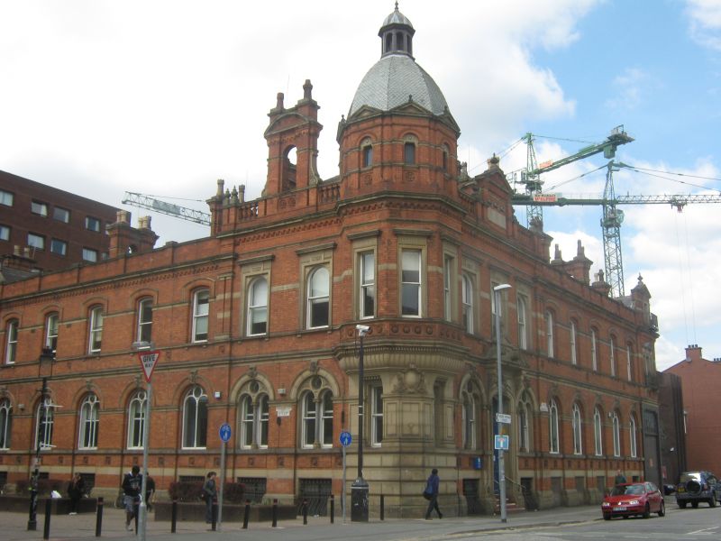
Chorlton Union Offices, in use as premises of Manchester
Polytechnic at the time of listing. 1880, by Mangnall and
Littlewood; altered. Red brick with sandstone dressings,
slate roofs. Rectangular plan on corner site. Two storeys
over basement, facades of 3:5:1 windows to Lower Ormond
Street and 2:5:1 windows to Cavendish Street, hinged on
an octagonal corner turret; with a band over
the basement windows, sill-bands to both floors, string-course
over ground floor, pilasters at the junctions, brick corbel
tables, moulded stone cornices and brick parapets (part
balustraded). The corner block has a symmetrical 3-bay facade
to Lower Ormond Street, including a segmental-headed doorway
which has an elaborate stone architrave and divided panelled
doors (up 4 steps), round-headed 2-light windows at ground
floor with shafts, round-headed lights and moulded stone heads
with mask keystones, round-headed sashes at 1st floor with
corniced architraves, and a balustraded parapet with
pedimented panel in the centre and urn finials. Its corner
turret to the left, of rusticated stone and panelled ashlar at
ground floor, has 2 narrow sashes and a central cartouche, a
gadrooned and dentilled cornice, above this a 3-sided oriel
with narrow sashed windows in corniced architraves, and an
octagonal turret with a small round-headed window and a
pediment to each side, and a domed roof with a lantern. The
2-bay left return is similar, but with a tall
segmental-pedimented pair of chimneys rising from the parapet.
The outer ranges of both facades are similar but slightly
lower and simpler, and the end bays have tripartite windows to
1st floor and pedimented attics. Various paired chimneys,
coupled to form arches, with cornices.
Listing NGR: SJ8422297028
External links are from the relevant listing authority and, where applicable, Wikidata. Wikidata IDs may be related buildings as well as this specific building. If you want to add or update a link, you will need to do so by editing the Wikidata entry.


Other nearby listed buildings
