Approximate Location Map
Large Map »
Latitude: 51.4771 / 51°28'37"N
Longitude: -2.7752 / 2°46'30"W
OS Eastings: 346257
OS Northings: 175638
OS Grid: ST462756
Mapcode National: GBR JH.L0MM
Mapcode Global: VH7C2.V46G
Plus Code: 9C3VF6GF+VW
Entry Name: Capenor Cottage
Listing Date: 4 August 1981
Grade: II
Source: Historic England
Source ID: 1220394
English Heritage Legacy ID: 394093
ID on this website: 101220394
Location: North Weston, North Somerset, BS20
County: North Somerset
Civil Parish: Portishead
Built-Up Area: Portishead
Traditional County: Somerset
Lieutenancy Area (Ceremonial County): Somerset
Tagged with: Cottage
1.
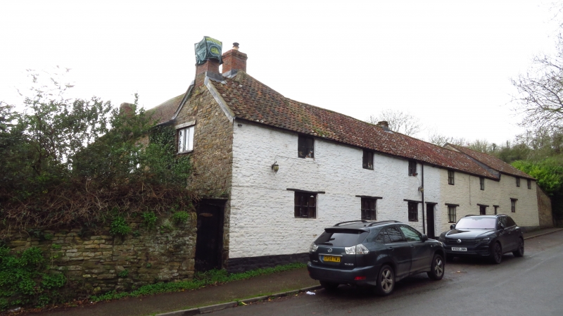
5121 ST MARY'S ROAD
Capenor Cottage
ST 4675 4/23
II
2.
L plan range of former outbuildings associated with Capenor Court (now demolished)
North range C18. Rubble, pantile roof. Two storeys, 5 windows plus 2 in
building at west end (former barns). Ground floor, 3-light mullioned wood
casements. East range: 3 windows, 2 storeys - but much altered.
Listing NGR: ST4625775638
External links are from the relevant listing authority and, where applicable, Wikidata. Wikidata IDs may be related buildings as well as this specific building. If you want to add or update a link, you will need to do so by editing the Wikidata entry.


Other nearby listed buildings
