Latitude: 53.5696 / 53°34'10"N
Longitude: -2.8846 / 2°53'4"W
OS Eastings: 341515
OS Northings: 408476
OS Grid: SD415084
Mapcode National: GBR 8W95.93
Mapcode Global: WH86H.NJLT
Plus Code: 9C5VH498+R5
Entry Name: Ormskirk Division Agricultural Club, with Forecourt and Steps
Listing Date: 11 August 1972
Grade: II
Source: Historic England
Source ID: 1221084
English Heritage Legacy ID: 386370
ID on this website: 101221084
Location: Ormskirk, West Lancashire, L39
County: Lancashire
District: West Lancashire
Electoral Ward/Division: Scott
Parish: Non Civil Parish
Built-Up Area: Ormskirk
Traditional County: Lancashire
Lieutenancy Area (Ceremonial County): Lancashire
Church of England Parish: Ormskirk St Peter and St Paul
Church of England Diocese: Liverpool
Tagged with: Architectural structure
ORMSKIRK
SD4108SE BURSCOUGH STREET 663-1/8/133 (West side) 11/08/72 No.65 Ormskirk Division Agricultural Club, with forecourt and steps
II
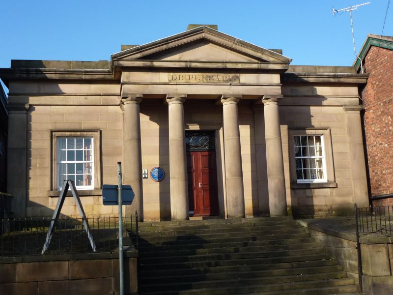
Dispensary, now club. 1830, altered. Sandstone ashlar facade (sides and rear of red brick in English garden wall bond), stone slate roof with central skylight. Rectangular plan, set back from road, with raised forecourt. Greek Revival style. Single storey, 3 bays, symmetrical, a pedimented tetrastyle Doric portico in the centre, pilastered corners, and an entablature with cornice and blocking course. Under the portico is a tall doorway with moulded architrave, glazed and panelled double doors, and a wide overlight with geometrical glazing bars; and to each side is a 16-pane sashed window with moulded architrave. The portico is approached by a flight of steps to the width of the centre bay, rising through a raised flagged forecourt with ashlar retaining walls. the left side wall has a blocked doorway in the centre and an inserted doorway near the rear corner. INTERIOR: central hall with pilastered walls (the left and right sides interrupted by inserted arches), coved ceiling and large rectangular skylight; otherwise, altered.
Listing NGR: SD4151508476
External links are from the relevant listing authority and, where applicable, Wikidata. Wikidata IDs may be related buildings as well as this specific building. If you want to add or update a link, you will need to do so by editing the Wikidata entry.


Other nearby listed buildings