Approximate Location Map
Large Map »
Latitude: 51.369 / 51°22'8"N
Longitude: 0.2073 / 0°12'26"E
OS Eastings: 553745
OS Northings: 165639
OS Grid: TQ537656
Mapcode National: GBR TT.GYB
Mapcode Global: VHHP6.JVYD
Plus Code: 9F329694+JW
Entry Name: Home Farmhouse
Listing Date: 1 August 1952
Grade: II
Source: Historic England
Source ID: 1222221
English Heritage Legacy ID: 414335
ID on this website: 101222221
Location: Eynsford, Sevenoaks, Kent, DA4
County: Kent
District: Sevenoaks
Civil Parish: Eynsford
Built-Up Area: Eynsford
Traditional County: Kent
Lieutenancy Area (Ceremonial County): Kent
Church of England Parish: Eynsford St Martin
Church of England Diocese: Rochester
Tagged with: Farmhouse
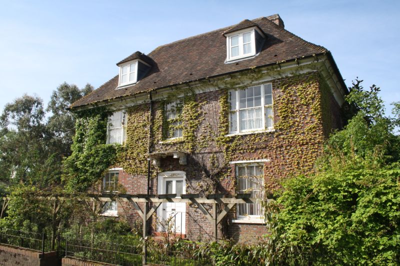
EYNSFORD RIVERSIDE
1.
5280
No 3
TQ 5365 11/80 1.8.52 (Home Farmhouse)
II
2.
Square early C18 house. Two storeys and attics, red brick and grey headers
alternately. Ripped tiled roof with 2 hipped dormers. Coved plastered eaves
cornice. Three sashes with glazing bars intact. Doorcase with flat hood on
enriched console brackets.
Listing NGR: TQ5374265634
External links are from the relevant listing authority and, where applicable, Wikidata. Wikidata IDs may be related buildings as well as this specific building. If you want to add or update a link, you will need to do so by editing the Wikidata entry.


Other nearby listed buildings
