Approximate Location Map
Large Map »
Latitude: 51.3821 / 51°22'55"N
Longitude: 0.2191 / 0°13'8"E
OS Eastings: 554523
OS Northings: 167121
OS Grid: TQ545671
Mapcode National: GBR TS.RX2
Mapcode Global: VHHP6.RJ6B
Plus Code: 9F3296J9+RJ
Entry Name: Saddlers House
Listing Date: 22 October 1982
Grade: II
Source: Historic England
Source ID: 1222231
English Heritage Legacy ID: 414353
ID on this website: 101222231
Location: Farningham, Sevenoaks, Kent, DA4
County: Kent
District: Sevenoaks
Civil Parish: Farningham
Built-Up Area: Eynsford
Traditional County: Kent
Lieutenancy Area (Ceremonial County): Kent
Church of England Parish: Farningham St Peter and St Paul
Church of England Diocese: Rochester
Tagged with: House
FARNINGHAM HIGH STREET
1.
5280 (north-east side)
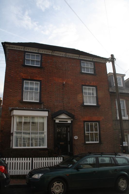
Saddlers House
TQ 5467 9/95
II GV
2.
C18. Three storeys and basement red brick. Hipped tiled roof with wooden
modillion eaves cornice. Three sashes with glazing bars missing. One modern
bay on the ground floor. Doorcase in moulded architrave surround with pediment
over, set at the head of 6 steps.
Listing NGR: TQ5452367121
External links are from the relevant listing authority and, where applicable, Wikidata. Wikidata IDs may be related buildings as well as this specific building. If you want to add or update a link, you will need to do so by editing the Wikidata entry.


Other nearby listed buildings
