Approximate Location Map
Large Map »
Latitude: 51.0468 / 51°2'48"N
Longitude: 0.4074 / 0°24'26"E
OS Eastings: 568843
OS Northings: 130255
OS Grid: TQ688302
Mapcode National: GBR NSG.7TT
Mapcode Global: FRA C6RC.0JN
Plus Code: 9F322CW4+PW
Entry Name: Field
Listing Date: 13 May 1987
Grade: II
Source: Historic England
Source ID: 1222440
English Heritage Legacy ID: 414575
ID on this website: 101222440
Location: Ticehurst, Rother, East Sussex, TN5
County: East Sussex
District: Rother
Civil Parish: Ticehurst
Built-Up Area: Ticehurst
Traditional County: Sussex
Lieutenancy Area (Ceremonial County): East Sussex
Church of England Parish: Ticehurst St Mary
Church of England Diocese: Chichester
Tagged with: Building
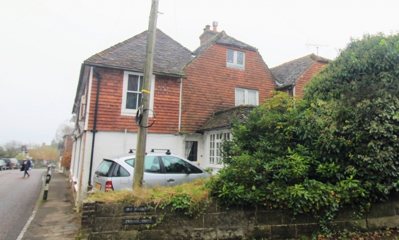
TQ 6830-6930 TICEHURST HIGH STREET
(south side)
34/22 Field
GV II
C17 building standing sideways to the road. Two storeys. Two windows facing north,
five windows facing west. North front red brick. West side is tile hung with whole
ground floor north front shop window. Tiled roof. Casement windows. The north
front has a small C19 shop front.
Listing NGR: TQ6884330255
External links are from the relevant listing authority and, where applicable, Wikidata. Wikidata IDs may be related buildings as well as this specific building. If you want to add or update a link, you will need to do so by editing the Wikidata entry.


Other nearby listed buildings
