Approximate Location Map
Large Map »
Latitude: 50.8439 / 50°50'38"N
Longitude: -0.6197 / 0°37'11"W
OS Eastings: 497274
OS Northings: 105839
OS Grid: SU972058
Mapcode National: GBR FJB.04G
Mapcode Global: FRA 96LV.VTJ
Plus Code: 9C2XR9VJ+H4
Entry Name: Manor Lodge and the West Wing
Listing Date: 5 June 1958
Last Amended: 20 September 1984
Grade: II
Source: Historic England
Source ID: 1222530
English Heritage Legacy ID: 414731
ID on this website: 101222530
Location: Walberton, Arun, West Sussex, BN18
County: West Sussex
District: Arun
Civil Parish: Walberton
Built-Up Area: Westergate
Traditional County: Sussex
Lieutenancy Area (Ceremonial County): West Sussex
Church of England Parish: Walberton
Church of England Diocese: Chichester
Tagged with: Architectural structure
SU 90NE WALBERTON THE STREET
8/407 (south side)
5.6.58
Manor Lodge and the
West Wing (formerly
listed as stables with
Walberton Manor)
II
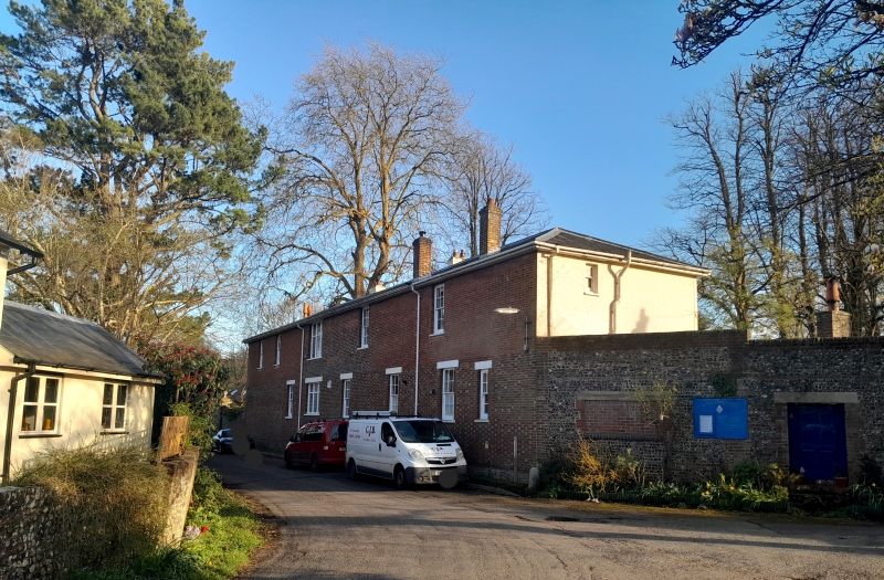
One building. Originally the Stables of Walberton House, now converted into two
houses. Early C19. Two storeys. Eleven windows. Red brick and grey headers, the
south front stuccoed. Hipped slate roof. Sash windows with glazing bars. Central
projection of three windows with doorway having hood over on brackets and door of six
fielded panels.
Listing NGR: SU9727105839
External links are from the relevant listing authority and, where applicable, Wikidata. Wikidata IDs may be related buildings as well as this specific building. If you want to add or update a link, you will need to do so by editing the Wikidata entry.


Other nearby listed buildings
