Approximate Location Map
Large Map »
Latitude: 51.2758 / 51°16'32"N
Longitude: 0.5212 / 0°31'16"E
OS Eastings: 575949
OS Northings: 155982
OS Grid: TQ759559
Mapcode National: GBR PR1.SQX
Mapcode Global: VHJMD.Z6D9
Plus Code: 9F327GGC+8F
Entry Name: Sir John Banks Almshouses
Listing Date: 30 July 1951
Grade: II
Source: Historic England
Source ID: 1222767
English Heritage Legacy ID: 173305
ID on this website: 101222767
Location: Maidstone, Kent, ME14
County: Kent
District: Maidstone
Electoral Ward/Division: High Street
Parish: Non Civil Parish
Built-Up Area: Maidstone
Traditional County: Kent
Lieutenancy Area (Ceremonial County): Kent
Tagged with: Almshouse
This list entry was subject to a Minor Amendment on 14/01/2020
TQ 7555 NE
1/104
ST FAITH'S STREET (south side)
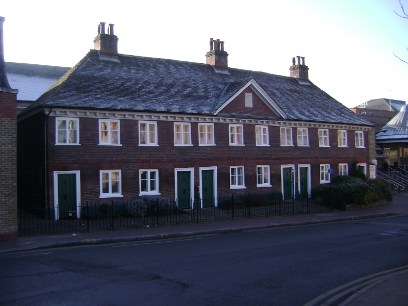
Nos 29 to 39 (odd) (Sir John Banks Almshouses)
(Formerly listed under FAITH STREET (south side))
30.7.51
GV
II
Built in 1700. Two storeys. Red brick. Hipped tiled roof. Wooden modillion eaves cornice. Twelve casement windows. Pediment over the centre of the building to the width of the four centre window bays. Brick stringcourse. The original inscription in the central pediment is now in the Maidstone Museum and the present one is a replica. Plain batten doors.
Nos 29 to 39 (odd) form a group.
Listing NGR: TQ7595855985
External links are from the relevant listing authority and, where applicable, Wikidata. Wikidata IDs may be related buildings as well as this specific building. If you want to add or update a link, you will need to do so by editing the Wikidata entry.


Other nearby listed buildings
