Approximate Location Map
Large Map »
Latitude: 51.7441 / 51°44'38"N
Longitude: -2.2135 / 2°12'48"W
OS Eastings: 385355
OS Northings: 205069
OS Grid: SO853050
Mapcode National: GBR 1MK.R5M
Mapcode Global: VH94Y.LF59
Plus Code: 9C3VPQVP+MH
Entry Name: Walcourt House
Listing Date: 25 June 1974
Grade: II
Source: Historic England
Source ID: 1222801
English Heritage Legacy ID: 418038
ID on this website: 101222801
Location: Stroud, Gloucestershire, GL5
County: Gloucestershire
District: Stroud
Civil Parish: Stroud
Built-Up Area: Stroud
Traditional County: Gloucestershire
Lieutenancy Area (Ceremonial County): Gloucestershire
Church of England Parish: Stroud St Laurence
Church of England Diocese: Gloucester
Tagged with: House
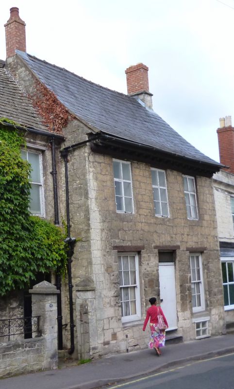
1. NELSON STREET
5227
(South Side )
No 12 (Walcourt House )
SO 8505 5/400
II GV
2.
Cl8. Stone. Welsh slate roof. 2 storeys. Wood modillion eaves cornice. 3
ranges of casement windows, with mullions and transoms on lst floor.
Nos 11 to 15 (consec) form a group.
Listing NGR: SO8535505069
External links are from the relevant listing authority and, where applicable, Wikidata. Wikidata IDs may be related buildings as well as this specific building. If you want to add or update a link, you will need to do so by editing the Wikidata entry.


Other nearby listed buildings
