Approximate Location Map
Large Map »
Latitude: 51.4985 / 51°29'54"N
Longitude: -0.2003 / 0°12'1"W
OS Eastings: 525018
OS Northings: 179264
OS Grid: TQ250792
Mapcode National: GBR C9.850
Mapcode Global: VHGQY.GLYM
Plus Code: 9C3XFQXX+CV
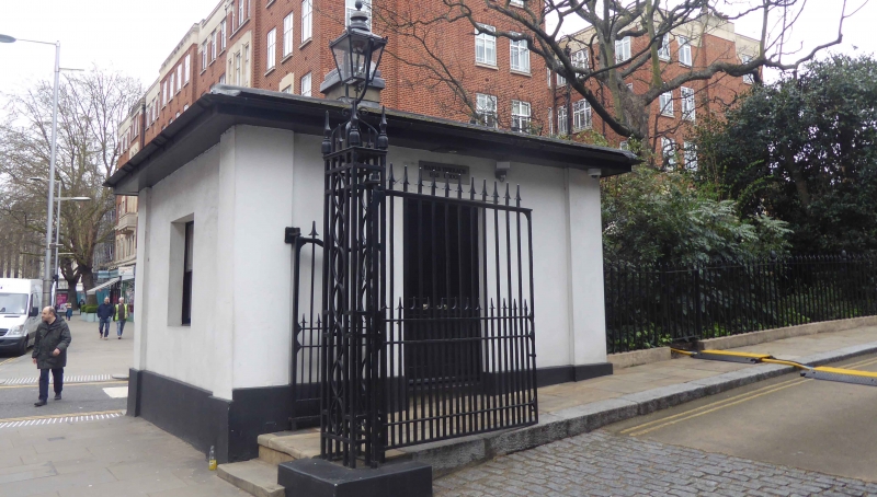
Entry Name: Lodge at North East End of Earl's Terrace
Listing Date: 7 November 1984
Grade: II
Source: Historic England
Source ID: 1222881
English Heritage Legacy ID: 418354
ID on this website: 101222881
Location: Kensington, Kensington and Chelsea, London, W8
County: London
District: Kensington and Chelsea
Electoral Ward/Division: Holland
Parish: Non Civil Parish
Built-Up Area: Kensington and Chelsea
Traditional County: Middlesex
Lieutenancy Area (Ceremonial County): Greater London
Church of England Parish: St Barnabas Addison Road
Church of England Diocese: London
Tagged with: Gatehouse
TQ 2579 SW KENSINGTON HIGH STREET W8
36/4
Lodge at NE end of
Earl's Terrace
II
Listing NGR: TQ2501879264
External links are from the relevant listing authority and, where applicable, Wikidata. Wikidata IDs may be related buildings as well as this specific building. If you want to add or update a link, you will need to do so by editing the Wikidata entry.


Other nearby listed buildings
