Approximate Location Map
Large Map »
Latitude: 51.1324 / 51°7'56"N
Longitude: 0.2606 / 0°15'38"E
OS Eastings: 558263
OS Northings: 139439
OS Grid: TQ582394
Mapcode National: GBR MPS.SVQ
Mapcode Global: VHHQD.GSMT
Plus Code: 9F3247J6+W6
Entry Name: Clarence House
Listing Date: 7 June 1974
Grade: II
Source: Historic England
Source ID: 1223657
English Heritage Legacy ID: 167960
Also known as: Glynlea and Glynlee Cottage
ID on this website: 101223657
Location: Royal Tunbridge Wells, Tunbridge Wells, Kent, TN1
County: Kent
District: Tunbridge Wells
Electoral Ward/Division: Culverden
Parish: Non Civil Parish
Built-Up Area: Royal Tunbridge Wells
Traditional County: Kent
Lieutenancy Area (Ceremonial County): Kent
Church of England Parish: Tunbridge Wells Holy Trinity with Christ Church
Church of England Diocese: Rochester
Tagged with: Cottage
This list entry was subject to a Minor Amendment on 03/06/2019
TQ 5839 SW
2/167
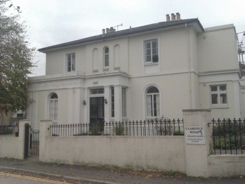
CLARENCE ROAD
No 1, Clarence House
(Formerly listed as No 1 (Glynlea and Glynlee Cottage)
GV
II
A mid C19 detached house in the Italianate style of irregular plan. Two storeys stuccoed. Hipped slate roof. Sashes and casement windows. Porch with square columns.
Nos 1 and 2 form a group.
Listing NGR: TQ5826439436
External links are from the relevant listing authority and, where applicable, Wikidata. Wikidata IDs may be related buildings as well as this specific building. If you want to add or update a link, you will need to do so by editing the Wikidata entry.


Other nearby listed buildings
