Approximate Location Map
Large Map »
Latitude: 53.6433 / 53°38'35"N
Longitude: -1.7503 / 1°45'0"W
OS Eastings: 416606
OS Northings: 416339
OS Grid: SE166163
Mapcode National: GBR JV69.VQ
Mapcode Global: WHCB2.2PTB
Plus Code: 9C5WJ6VX+8V
Entry Name: Greenhead
Listing Date: 29 September 1978
Grade: II
Source: Historic England
Source ID: 1223878
English Heritage Legacy ID: 419765
ID on this website: 101223878
Location: Greenside, Kirklees, West Yorkshire, HD5
County: Kirklees
Electoral Ward/Division: Almondbury
Parish: Non Civil Parish
Built-Up Area: Huddersfield
Traditional County: Yorkshire
Lieutenancy Area (Ceremonial County): West Yorkshire
Church of England Parish: Kirkheaton St John the Baptist
Church of England Diocese: Leeds
Tagged with: Building
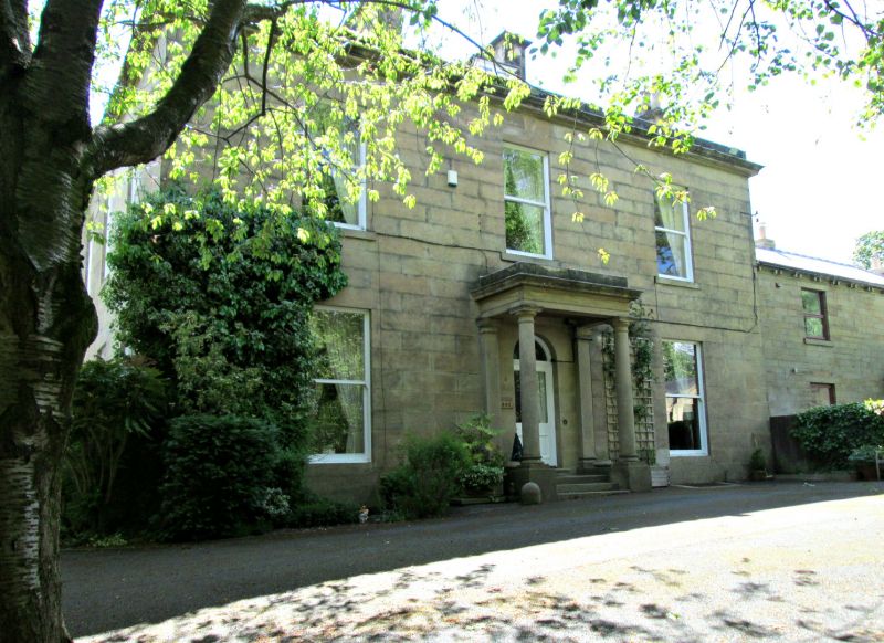
WAKEFIELD ROAD
1.
5113
(South Side)
Nos 390 and 392
(Greenhead)
SE 1616 35/1338
II
2.
Mid C19. Ashlar. Hipped stone slate roof. 2 storeys. Moulded eaves cornice.
3 ranges of sashes on one elevation, 4 on another. Door with 2 moulded panels,
semi-circular fanlight in porch with 2 Tuscan columns, full entablature and
blocking course.
Listing NGR: SE1660616339
External links are from the relevant listing authority and, where applicable, Wikidata. Wikidata IDs may be related buildings as well as this specific building. If you want to add or update a link, you will need to do so by editing the Wikidata entry.


Other nearby listed buildings
