Approximate Location Map
Large Map »
Latitude: 51.5121 / 51°30'43"N
Longitude: -0.204 / 0°12'14"W
OS Eastings: 524728
OS Northings: 180767
OS Grid: TQ247807
Mapcode National: GBR C8.F7Z
Mapcode Global: VHGQY.F805
Plus Code: 9C3XGQ6W+RC
Entry Name: 17-29, Stanley Gardens W11
Listing Date: 15 April 1969
Grade: II
Source: Historic England
Source ID: 1226837
English Heritage Legacy ID: 424333
ID on this website: 101226837
Location: Notting Hill, Kensington and Chelsea, London, W11
County: London
District: Kensington and Chelsea
Electoral Ward/Division: Colville
Parish: Non Civil Parish
Built-Up Area: Kensington and Chelsea
Traditional County: Middlesex
Lieutenancy Area (Ceremonial County): Greater London
Church of England Parish: St Peter Notting Hill
Church of England Diocese: London
Tagged with: Building
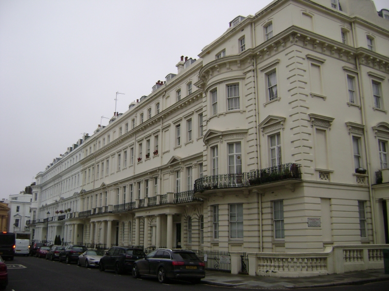
TQ 2480 NE STANLEY GARDENS W11
19/9
15.4.69 Nos 17 to 29 (consec)
GV
II
Mid C19. Terrace of stucco houses. Elaborate classical manner. Four storeys plus
basement. Ground floor rusticated with Doric porticos arranged in pairs. Iron railed
balcony to first floor, windows framed by pilaster order. End houses have bow windows
rising to level of main cornice (below top storey). Rear elevations also stuccoed.
Terrace returns with Stanley Crescent and Kensington Park Road, and creates a formal
composition with Nos 1-16 (consec) St Peter's Church and 10-11 Stanley Crescent.
Listing NGR: TQ2472880767
External links are from the relevant listing authority and, where applicable, Wikidata. Wikidata IDs may be related buildings as well as this specific building. If you want to add or update a link, you will need to do so by editing the Wikidata entry.


Other nearby listed buildings
