Latitude: 50.9557 / 50°57'20"N
Longitude: -0.5354 / 0°32'7"W
OS Eastings: 502965
OS Northings: 118382
OS Grid: TQ029183
Mapcode National: GBR GJD.3G9
Mapcode Global: FRA 96RL.57M
Plus Code: 9C2XXF47+7R
Entry Name: Stopham Bridge
Listing Date: 22 February 1955
Grade: I
Source: Historic England
Source ID: 1226929
English Heritage Legacy ID: 424459
ID on this website: 101226929
Location: Stopham, Chichester, West Sussex, RH20
County: West Sussex
District: Chichester
Civil Parish: Stopham
Traditional County: Sussex
Lieutenancy Area (Ceremonial County): West Sussex
Church of England Parish: Stopham St Mary the Virgin
Church of England Diocese: Chichester
Tagged with: Bridge Road bridge
TQ Ol NW STOPHAM
14/146 Stopham Bridge
22.2.55 I
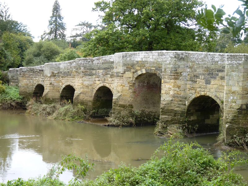
Bridge. This is partly in Horsham District (formerly Chanctonbury Rural District).
Scheduled Ancient Monument. Dallaway's History of West Sussex and all the early
authorities gave the date of the Bridge as 1309. But the correct date is probably
1422-3. One span was destroyed in the Civil War and replaced by a "drawbridge".
This was fenced in 1650. The centre arch was raised in 1821 and has the inscription
J.S.A. July 7 1822. It was badly damaged by army lorries in the late war. It was
repaired after the war but has been damaged again since. It is built of Midhurst stone and Hythe sandstone, and consists of a high segmental arch in the centre and 3 lower round-headed ones on each side. There are blunt cutwaters between the arches. These are continued above the water level on the south side as half-hexagonal buttresses and form recesses of this shape for pedestrians on the bridge. On the north side the cutwaters are continued the whole height of the bridge as cutwaters and form triangular recesses on the Bridge.
Listing NGR: TQ0296518382
External links are from the relevant listing authority and, where applicable, Wikidata. Wikidata IDs may be related buildings as well as this specific building. If you want to add or update a link, you will need to do so by editing the Wikidata entry.


Other nearby listed buildings