Approximate Location Map
Large Map »
Latitude: 51.4847 / 51°29'4"N
Longitude: -0.17 / 0°10'12"W
OS Eastings: 527162
OS Northings: 177779
OS Grid: TQ271777
Mapcode National: GBR 6P.0Y
Mapcode Global: VHGQZ.0YG7
Plus Code: 9C3XFRMH+VX
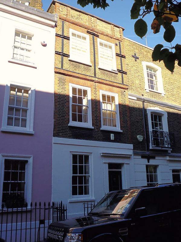
Entry Name: 20, Upper Cheyne Row SW3
Listing Date: 24 June 1954
Grade: II
Source: Historic England
Source ID: 1227059
English Heritage Legacy ID: 424650
ID on this website: 101227059
Location: Chelsea, Kensington and Chelsea, London, SW3
County: London
District: Kensington and Chelsea
Electoral Ward/Division: Chelsea Riverside
Parish: Non Civil Parish
Built-Up Area: Kensington and Chelsea
Traditional County: Middlesex
Lieutenancy Area (Ceremonial County): Greater London
Church of England Parish: All Saints (Chelsea Old Church)
Church of England Diocese: London
Tagged with: Building
TQ 2777 NW UPPER CHEYNE ROW SW3
62/20
24.6.54
No 20
GV
II
House. Circa 1716. Three storeys and basement. Two windows wide. Amber brick,
stucco ground floor. Red brick. Moulded cornice below panelled parapet and moulded
band 2nd floor. Red gauged flat arches and dressings to flush framed windows. Stucco
pilasters and cornice to entrance. Wrought iron area railings.
Listing NGR: TQ2716177782
External links are from the relevant listing authority and, where applicable, Wikidata. Wikidata IDs may be related buildings as well as this specific building. If you want to add or update a link, you will need to do so by editing the Wikidata entry.


Other nearby listed buildings
