Approximate Location Map
Large Map »
Latitude: 51.4846 / 51°29'4"N
Longitude: -0.1703 / 0°10'12"W
OS Eastings: 527144
OS Northings: 177770
OS Grid: TQ271777
Mapcode National: GBR 5P.YZ
Mapcode Global: VHGQZ.0YB9
Plus Code: 9C3XFRMH+RV
Entry Name: 28A, Upper Cheyne Row SW3
Listing Date: 7 November 1984
Grade: II
Source: Historic England
Source ID: 1227062
English Heritage Legacy ID: 424653
ID on this website: 101227062
Location: Chelsea, Kensington and Chelsea, London, SW3
County: London
District: Kensington and Chelsea
Electoral Ward/Division: Chelsea Riverside
Parish: Non Civil Parish
Built-Up Area: Kensington and Chelsea
Traditional County: Middlesex
Lieutenancy Area (Ceremonial County): Greater London
Church of England Parish: All Saints (Chelsea Old Church)
Church of England Diocese: London
Tagged with: Building
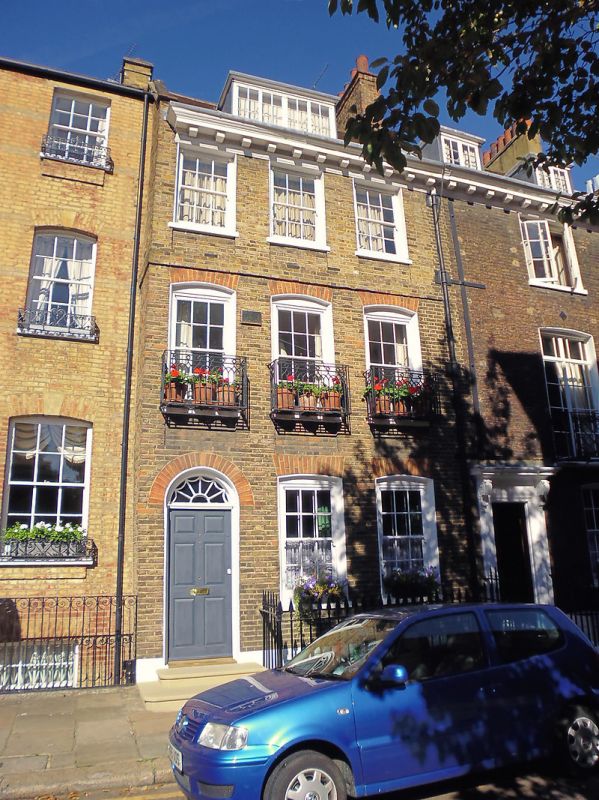
TQ 2777 NW UPPER CHEYNE ROW SW3
62/17
No 28A
GV
II
House. Rebuilt front of three windows wide. (Survey of London, Vols IV and XI).
Area railings.
Listing NGR: TQ2714377772
External links are from the relevant listing authority and, where applicable, Wikidata. Wikidata IDs may be related buildings as well as this specific building. If you want to add or update a link, you will need to do so by editing the Wikidata entry.


Other nearby listed buildings
