Latitude: 52.9701 / 52°58'12"N
Longitude: -1.0374 / 1°2'14"W
OS Eastings: 464740
OS Northings: 341852
OS Grid: SK647418
Mapcode National: GBR 9JV.VYR
Mapcode Global: WHFHZ.1L8W
Plus Code: 9C4WXXC7+32
Entry Name: Lowe's Farmhouse and Adjoining Boundary Wall
Listing Date: 13 October 1966
Last Amended: 27 April 1987
Grade: II
Source: Historic England
Source ID: 1227548
English Heritage Legacy ID: 425411
ID on this website: 101227548
Location: Stoke Bardolph, Gedling, Nottinghamshire, NG14
County: Nottinghamshire
District: Gedling
Civil Parish: Stoke Bardolph
Traditional County: Nottinghamshire
Lieutenancy Area (Ceremonial County): Nottinghamshire
Church of England Parish: Burton Joyce with Bulcote and Stoke Bardolph
Church of England Diocese: Southwell and Nottingham
Tagged with: Farmhouse
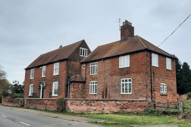
STOKE BARDOLPH RIVERSIDE SK 64 SW (west side) 7/148 Lowe's Farmhouse and adjoining boundary wall (fomerly listed as Farmhouse to South of Ferry Boat Inn) 13.10.66 II Farmhouse, now a house. Early C18. Extended early C19. Brick with gabled and hipped pantile roofs. Plinth, partly rendered, dentillated eaves. 2 ridge, single gable and single side wall stacks. 2 storeys plus garrets, 5 bays. L-plan. Windows are mainly glazing bar sashes. Ground floor front windows have segmental heads. South front has central brick and stone double steps with iron railings. Door with overlight and curved brackets to flat hood. Flanked by single sashes. To right, lower set back C19 addition with 2 casements. Above, 3 sashes, the central one smallest. To right, 2 casements. West gable has a sash on each floor and above again, C20 casement. Lower 2 storey rear wing has first floor band. West side has, to left, door and blocked doorway. To right, a casement. Above, 2 casements. To east, a casement on each floor. Rear elevation has to left a door and a casement. To right, door with segmental head and hood. Above to left, 2 casements. East gable has large casement to garret. C19 addition has to east, a casement and above, 2 casements. Adjoining boundary wall, early C19, brick with gabled brick coping, has round corner and wooden gate. Approx. 40 M long.
Listing NGR: SK6474041852
External links are from the relevant listing authority and, where applicable, Wikidata. Wikidata IDs may be related buildings as well as this specific building. If you want to add or update a link, you will need to do so by editing the Wikidata entry.


Other nearby listed buildings