Latitude: 53.0748 / 53°4'29"N
Longitude: -0.8089 / 0°48'31"W
OS Eastings: 479897
OS Northings: 353723
OS Grid: SK798537
Mapcode National: GBR CLN.6B2
Mapcode Global: WHFHH.KZ16
Plus Code: 9C5X35FR+WF
Entry Name: 29 Carter Gate
Listing Date: 19 May 1971
Last Amended: 16 May 2024
Grade: II
Source: Historic England
Source ID: 1227883
English Heritage Legacy ID: 384933
ID on this website: 101227883
Location: Newark-on-Trent, Newark and Sherwood, Nottinghamshire, NG24
County: Nottinghamshire
District: Newark and Sherwood
Civil Parish: Newark
Built-Up Area: Newark-on-Trent
Traditional County: Nottinghamshire
Lieutenancy Area (Ceremonial County): Nottinghamshire
Church of England Parish: Newark-upon-Trent with Coddington
Church of England Diocese: Southwell and Nottingham
Tagged with: Building
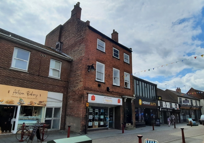
A three-storey former house constructed during the late C18 in exposed red brick, later converted to shop use across the ground floor with new brickwork and new windows across all floors in the mid-C20.
A three-storey former house constructed during the late C18 in exposed red brick, later
converted to shop use across the ground floor with new brickwork and new windows across all floors in the mid-C20.
MATERIALS: the front elevation is of exposed brick in a Flemish bond. Where parts of the ground floor have been recessed to insert a new C20 shopfront, dark red brickwork has been used in a stretcher bond. The gabled flank projects forward of the building line on the northern side, revealing an elevation of Common Bond brickwork with multiple later repairs, similar to the visible upper gable of the southern side flank.
PLAN: the building is of three-storeys with entry for the upper storeys through a main door to the south. Two flats now exist on the first and second floors following late-C20 conversion. The ground floor has been converted to a retail unit and is accessed directly through a door to the right, beneath a recessed underside.
EXTERIOR: the ground floor retail unit is recessed with a large plate-glass front and single-pane metal door. To the south, the original main door and timber doorcase remains and now provides access to the upper floors. This is a timber, six-panel door accessed via three, rounded stone steps, flanked by timber scrapers, now with cast iron element removed. A flat timber hood rests on carved timber console brackets. An early-C20 leaded, stained-glass overlight sits beneath the hood. A three-brick plat band runs across the façade between ground and first floors. The first and second floors have single pane sash windows, across all three bays, with the first floor full-height and second floor half-height, all beneath flat brick arches. The central window on the second floor is false and is painted. The pitched roof has pantiles with two gable stacks.
Newark appears as Newerche in the 1086 Domesday Book. It’s original name Niweweorche (meaning 'New work') is likely associated with the meaning "New fort". The site of Newark Castle was founded by Robert Bloet, Bishop of Lincoln in 1073 and rebuilt in stone from 1123-1133. A bridge over the Trent was built under charter from Henry I at a similar time. In the C15 and C16, Newark became a prosperous market town centred on the wool and cloth trade and characterised by a dense street pattern surrounding the market square. It was incorporated by the Crown in 1549. Significant development occurred during the C18 in response to growing trade along the Great North Road: with a number of handsome terraced Georgian buildings evident from this time. In 1775 a new bridge over the River Trent was constructed, it was further improved in 1848 and forms the current ‘Trent Bridge’. The Market Place was rebuilt in the C18 with coaching inns; the houses of leading citizens and the splendid new Town Hall (1773) by John Carr. By 1801 Newark had a population of 6,730 and was Nottinghamshire’s second town.
‘Gate’ is a Saxon word for street or way and this reflects Carter Gate’s early medieval origins as part of the Saxon burgh. As part of the medieval core of the city, the relatively narrow street is densely developed. A distinctive characteristic of the medieval street was buildings arranged around courtyards accessed via gates onto Carter Gate. Some survive with others surviving simply as passages in later buildings now leading to built up areas behind the primary buildings fronting the street.
The brick building at 29 Carter Gate would originally have been built as a single house in the late C18, with minor alterations made in the late C19. The most significant alterations were made in the C20, principally the replacement of windows and the conversion of the ground floor into a metalframed retail unit. Further changes in the late C20 involved the conversion of the first and second floors into two flats.
External links are from the relevant listing authority and, where applicable, Wikidata. Wikidata IDs may be related buildings as well as this specific building. If you want to add or update a link, you will need to do so by editing the Wikidata entry.


Other nearby listed buildings