Approximate Location Map
Large Map »
Latitude: 53.0751 / 53°4'30"N
Longitude: -0.8089 / 0°48'31"W
OS Eastings: 479896
OS Northings: 353761
OS Grid: SK798537
Mapcode National: GBR CLN.69Z
Mapcode Global: WHFHH.KY1X
Plus Code: 9C5X35GR+2F
Entry Name: 40-44, Carter Gate
Listing Date: 29 September 1950
Last Amended: 13 August 1992
Grade: II
Source: Historic England
Source ID: 1228192
English Heritage Legacy ID: 384937
ID on this website: 101228192
Location: Newark-on-Trent, Newark and Sherwood, Nottinghamshire, NG24
County: Nottinghamshire
District: Newark and Sherwood
Civil Parish: Newark
Built-Up Area: Newark-on-Trent
Traditional County: Nottinghamshire
Lieutenancy Area (Ceremonial County): Nottinghamshire
Church of England Parish: Newark-upon-Trent with Coddington
Church of England Diocese: Southwell and Nottingham
Tagged with: Building
NEWARK ON TRENT
SK7953NE CARTER GATE
619-1/8/88 (North West side)
29/09/50 Nos.40-44 (Even)
(Formerly Listed as:
CARTER GATE
No.40)
(Formerly Listed as:
CARTER GATE
Nos.42-44 (Even))
GV II
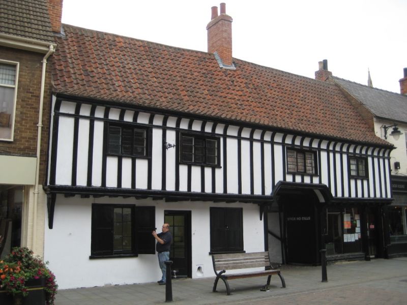
3 houses, now 2 shops. Early C17 with late C19 rear addition,
altered and restored C20. Close studding with rendered
nogging, brick, and rendered underbuild, with pantile roof.
Single gable and single ridge stacks. Jettied first floor with
billeted bresummer, coved eaves. 2 storeys; 4 window range
with 3 three-light Yorkshire sashes and to right a 2-light
casement. Off-centre inserted carriage opening with close
boarded doors. To its right, a late C19 shopfront with
panelled pilasters, 2-light mullioned window and glazed door.
To left, a close boarded door with scraper, flanked by single
Yorkshire sashes with framed shutters. Under the carriage
opening, arch braced box framing with mid rail and rendered
nogging. Catslide roof at rear.
Listing NGR: SK7989653761
External links are from the relevant listing authority and, where applicable, Wikidata. Wikidata IDs may be related buildings as well as this specific building. If you want to add or update a link, you will need to do so by editing the Wikidata entry.


Other nearby listed buildings
