Approximate Location Map
Large Map »
Latitude: 50.7327 / 50°43'57"N
Longitude: -2.7579 / 2°45'28"W
OS Eastings: 346606
OS Northings: 92835
OS Grid: SY466928
Mapcode National: GBR PP.0C41
Mapcode Global: FRA 5734.PCJ
Plus Code: 9C2VP6MR+3R
Entry Name: 23, South Street
Listing Date: 19 September 1975
Grade: II
Source: Historic England
Source ID: 1227979
English Heritage Legacy ID: 402340
ID on this website: 101227979
Location: Bridport, Dorset, DT6
County: Dorset
Civil Parish: Bridport
Built-Up Area: Bridport
Traditional County: Dorset
Lieutenancy Area (Ceremonial County): Dorset
Church of England Parish: Bridport St Mary
Church of England Diocese: Salisbury
Tagged with: Building
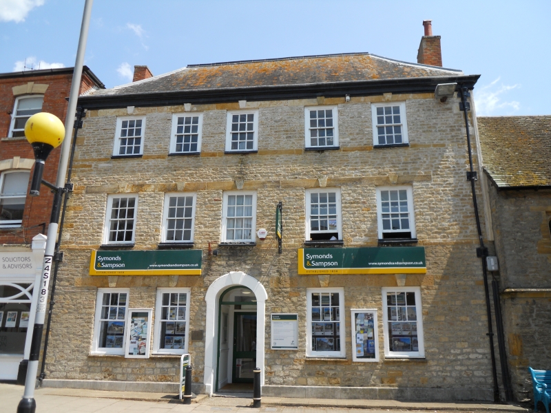
1.
1591 SOUTH STREET
(East Side)
No 23
SY 4692 1/116
II
2.
Early or mid C18. Stucco. Hipped slate roof. 3 storeys. Moulded cornice
with concealed gutter. 5 ranges of flush-framed sashes with bull-nosed sills,
glazing bars and keystones. Rear mostly coursed rubble with pigeon holes.
2 storey plastered wing with old plain tiled hipped roof, Old outbuildings.
Listing NGR: SY4660692835
External links are from the relevant listing authority and, where applicable, Wikidata. Wikidata IDs may be related buildings as well as this specific building. If you want to add or update a link, you will need to do so by editing the Wikidata entry.


Other nearby listed buildings
