Approximate Location Map
Large Map »
Latitude: 50.7308 / 50°43'51"N
Longitude: -2.7577 / 2°45'27"W
OS Eastings: 346622
OS Northings: 92631
OS Grid: SY466926
Mapcode National: GBR PP.0K5T
Mapcode Global: FRA 5734.X1K
Plus Code: 9C2VP6JR+8W
Entry Name: 71-79, South Street
Listing Date: 19 September 1975
Grade: II
Source: Historic England
Source ID: 1228007
English Heritage Legacy ID: 402499
ID on this website: 101228007
Location: New Zealand, Dorset, DT6
County: Dorset
Civil Parish: Bridport
Built-Up Area: Bridport
Traditional County: Dorset
Lieutenancy Area (Ceremonial County): Dorset
Church of England Parish: Bridport St Mary
Church of England Diocese: Salisbury
Tagged with: Building
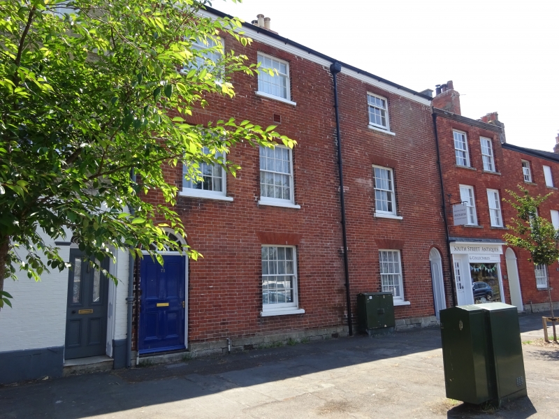
1.
5l91 SOUTH STREET
(East Side)
Nos 71 to 79 (odd)
SY 4692 1/126
II GV
2.
Late C18 or early C19. Red brick. 3 storeys. Moulded eaves cornices. Sashes
with glazing bars. Doors with semi-circular fanlights. Nos 77 and 79 are
1 3-window block. One small shop front.
Nos 53 to 81 (odd) form a group.
Listing NGR: SY4662392625
External links are from the relevant listing authority and, where applicable, Wikidata. Wikidata IDs may be related buildings as well as this specific building. If you want to add or update a link, you will need to do so by editing the Wikidata entry.


Other nearby listed buildings
