Latitude: 53.5054 / 53°30'19"N
Longitude: -2.4117 / 2°24'41"W
OS Eastings: 372793
OS Northings: 401049
OS Grid: SD727010
Mapcode National: GBR CWLX.P4
Mapcode Global: WH987.X5R0
Plus Code: 9C5VGH4Q+58
Entry Name: Boothstown Lancashire Mines Rescue Station
Listing Date: 21 January 1994
Grade: II
Source: Historic England
Source ID: 1228029
English Heritage Legacy ID: 400066
ID on this website: 101228029
Location: Boothstown, Salford, Greater Manchester, M28
County: Salford
Electoral Ward/Division: Boothstown and Ellenbrook
Parish: Non Civil Parish
Built-Up Area: Worsley
Traditional County: Lancashire
Lieutenancy Area (Ceremonial County): Greater Manchester
Church of England Parish: Worsley St Mark
Church of England Diocese: Manchester
Tagged with: Building
The following building shall be added:
WORSLEY ELLENBROOK ROAD SD 70 SW 1479-/1/10003 Boothstown Lancashire Mines Rescue Station II
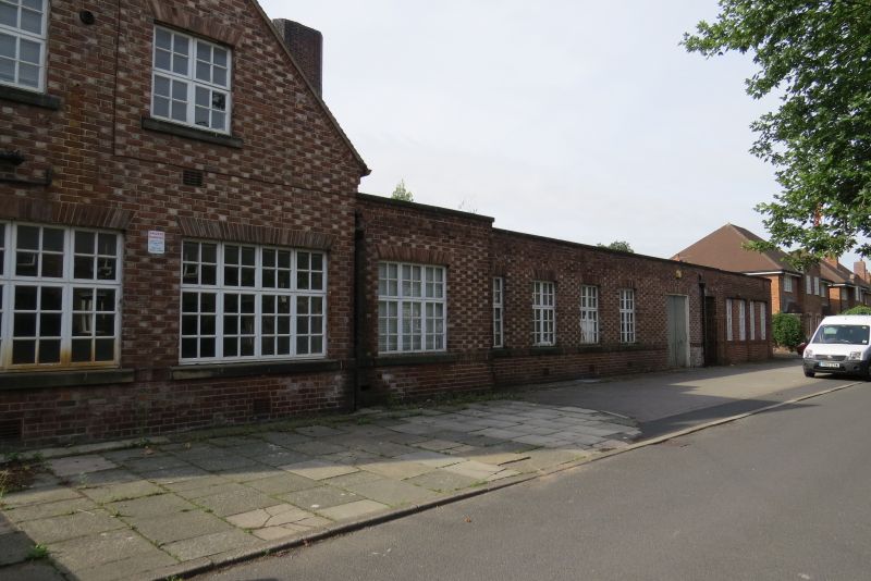
Mines Rescue Station. 1932-3 with subsequent minor alterations and additions. By Bradshawe,Hope and Gass of Bolton for the Lancashire and Cheshire Coal Owners. Red brick laid to Flemish bond,with light-coloured headers and ashlar copings.Hipped roof with plain tile covering and tall side wall brick stacks. Plan; 2 storey range to road frontage,with service,laboratory and storage rooms flanking unfloored 3 bay garage for rescue vehicles.Long,flat roofed single storey rear range incorporating smaller glazed pitched roofs over observation halls flanking unlit training galleries. East elevation; 2 storeys,7 bays, with advanced outer 2-bay wings flanking set-back 3 bay centre with shallow pitch-roofed glazed canopy linking the wings. These have stacked 4-light windows beneath brick soldier arched heads. Transomed timber glazing bar frames. Shallow cambered parapets to wings,with pitched copings and end finials. Centre 3 bays with folding triple half-glazed garage doors,above which are 4-light flat-roofed dormer windows. Gabled side elevations to north and south extend beyond line of frontage range. Rear elevation on north side with tiered louvred ventilator serving station laboratory. Stepped 7-bay single storey range to rear with flat roof incorporates tall square chimney.Additional garaging in extension with curved walling. Interior retains much of its original form and fittings,including those within the training galleries,and is a remarkably complete and rare example of a 'state of the art' mines rescue station ,with vehicle garaging,gas and equipment testing facilities, laboratory,oxygen and equipment storage areas and training galleries with observation halls. The building was opened on November 18th 1933.
Listing NGR: SD7279301049
External links are from the relevant listing authority and, where applicable, Wikidata. Wikidata IDs may be related buildings as well as this specific building. If you want to add or update a link, you will need to do so by editing the Wikidata entry.


Other nearby listed buildings