Latitude: 53.5752 / 53°34'30"N
Longitude: -2.5985 / 2°35'54"W
OS Eastings: 360464
OS Northings: 408896
OS Grid: SD604088
Mapcode National: GBR BW93.74
Mapcode Global: WH97S.1DWK
Plus Code: 9C5VHCG2+3H
Entry Name: Windmill
Listing Date: 10 May 1988
Grade: II
Source: Historic England
Source ID: 1228084
English Heritage Legacy ID: 402593
ID on this website: 101228084
Location: Haigh, Wigan, Greater Manchester, WN2
County: Wigan
Civil Parish: Haigh
Built-Up Area: Aspull
Traditional County: Lancashire
Lieutenancy Area (Ceremonial County): Greater Manchester
Church of England Parish: Haigh and Aspull St David
Church of England Diocese: Liverpool
Tagged with: Windmill
SD 60 NW
6/52
HAIGH
COPPERAS LANE
(south side)
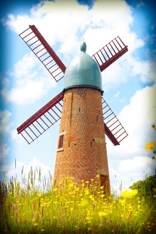
Windmill
II
Windmill. Mid C19. For brewery of J. Sumner. Brick. Tapering
round tower with ribbed timber cap and finial; 4 sails.
Tower has blocked entrance, 2 blocked windows and 3 blocked
cellar openings with plain stone lintels.
Listing NGR: SD6046408896
External links are from the relevant listing authority and, where applicable, Wikidata. Wikidata IDs may be related buildings as well as this specific building. If you want to add or update a link, you will need to do so by editing the Wikidata entry.


Other nearby listed buildings