Approximate Location Map
Large Map »
Latitude: 50.6978 / 50°41'52"N
Longitude: -3.2503 / 3°15'1"W
OS Eastings: 311791
OS Northings: 89429
OS Grid: SY117894
Mapcode National: GBR P8.9PVM
Mapcode Global: FRA 4727.HJM
Plus Code: 9C2RMPXX+4V
Entry Name: Woolbrook Farmhouse Including Outbuildings, (Part of Same Block)
Listing Date: 12 November 1973
Grade: II
Source: Historic England
Source ID: 1228505
English Heritage Legacy ID: 403111
ID on this website: 101228505
Location: Higher Woolbrook, East Devon, EX10
County: Devon
District: East Devon
Civil Parish: Sidmouth
Built-Up Area: Sidmouth
Traditional County: Devon
Lieutenancy Area (Ceremonial County): Devon
Church of England Parish: Woolbrook St Francis of Assisi
Church of England Diocese: Exeter
Tagged with: Farmhouse Thatched farmhouse
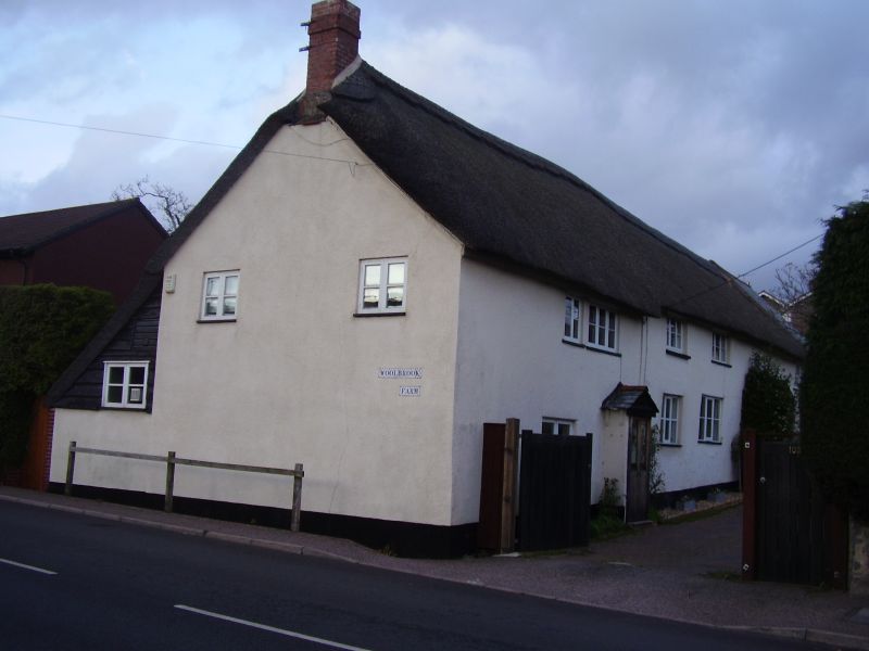
WOOLBROOK ROAD
1.
1633
Woolbrook Farmhouse
including outbuildings,
(part of same block)
SY 18 NW 14/162
II
2.
C17/C18. Low 2 storey front at right angles to road including in same
range outbuildings at north end. Cob walls to residential part, stone
rubble outbuildings. Thatched roof over all. 4 windows to residential
part, mostly 3-light easements. 2 enclosed gabled porches. To rear part
of roof is carried down over ground floor. External stone chimney with
offsets, tall red brick stack. The rear elevation is partly refaced in
brick.
Listing NGR: SY1179189429
External links are from the relevant listing authority and, where applicable, Wikidata. Wikidata IDs may be related buildings as well as this specific building. If you want to add or update a link, you will need to do so by editing the Wikidata entry.


Other nearby listed buildings
