Latitude: 52.9231 / 52°55'22"N
Longitude: -1.4782 / 1°28'41"W
OS Eastings: 435180
OS Northings: 336309
OS Grid: SK351363
Mapcode National: GBR PKF.2J
Mapcode Global: WHDGT.8SCH
Plus Code: 9C4WWGFC+6P
Entry Name: 51, Sadler Gate
Listing Date: 20 June 1952
Grade: II
Source: Historic England
Source ID: 1229474
English Heritage Legacy ID: 404294
ID on this website: 101229474
Location: Derby, Derbyshire, DE1
County: City of Derby
Electoral Ward/Division: Arboretum
Parish: Non Civil Parish
Built-Up Area: Derby
Traditional County: Derbyshire
Lieutenancy Area (Ceremonial County): Derbyshire
Church of England Parish: All Saints Derby
Church of England Diocese: Derby
Tagged with: Building
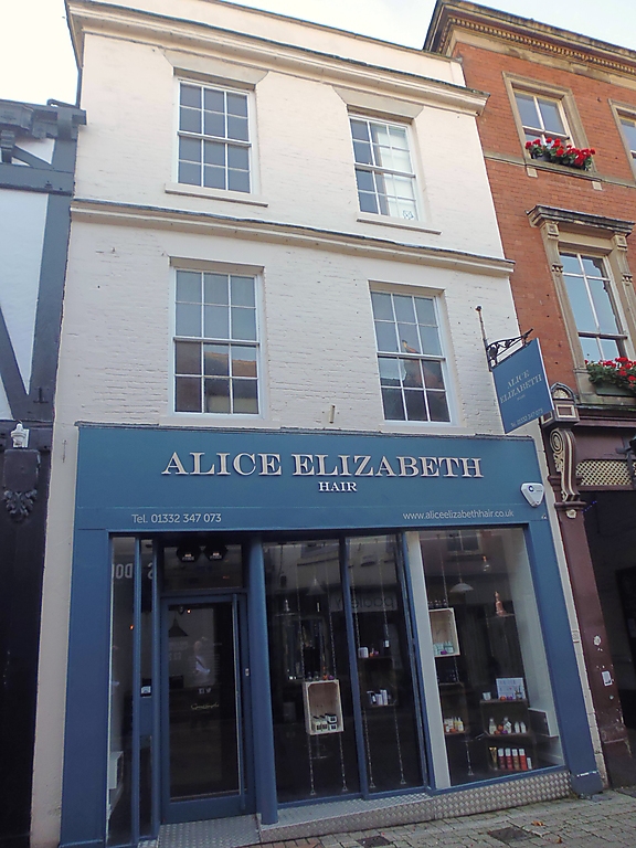
SADLER GATE
1.
5170
(South Side)
No 51
SK 3536 SW 1/272 20.6.52.
II
2.
Late C17. Painted brick; 3 storeys; 2 C18 windows to 1st and 2nd storeys; cornice
above each storey, shallow parapet. Partly curved gable visible above later wing
of the Old Bell Hotel, has walled up 4-light mullioned and transomed window.
Listing NGR: SK3518036309
External links are from the relevant listing authority and, where applicable, Wikidata. Wikidata IDs may be related buildings as well as this specific building. If you want to add or update a link, you will need to do so by editing the Wikidata entry.


Other nearby listed buildings