Approximate Location Map
Large Map »
Latitude: 53.6519 / 53°39'6"N
Longitude: -1.8292 / 1°49'45"W
OS Eastings: 411387
OS Northings: 417282
OS Grid: SE113172
Mapcode National: GBR HVN6.SM
Mapcode Global: WHCB0.WG4Q
Plus Code: 9C5WM52C+Q8
Entry Name: 35-39, Quarmby Fold
Listing Date: 29 September 1978
Grade: II
Source: Historic England
Source ID: 1230098
English Heritage Legacy ID: 404969
ID on this website: 101230098
Location: Oakes, Kirklees, West Yorkshire, HD3
County: Kirklees
Electoral Ward/Division: Lindley
Parish: Non Civil Parish
Built-Up Area: Huddersfield
Traditional County: Yorkshire
Lieutenancy Area (Ceremonial County): West Yorkshire
Church of England Parish: Lindley St Stephen
Church of England Diocese: Leeds
Tagged with: Building
1.
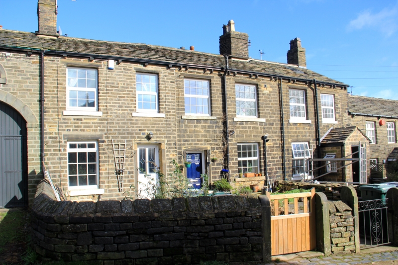
5113 QUARMBY FOLD
Nos 35 to 39 (odd)
SE 1117 26/1096
II
2.
Early C19. Hammer dressed stone. Pitched stone slate roof. Coped gable on
cut kneeler. 2 storeys. 6 ranges of modern windows in C19 openings, 4 with
glazing bars.
Listing NGR: SE1138717282
External links are from the relevant listing authority and, where applicable, Wikidata. Wikidata IDs may be related buildings as well as this specific building. If you want to add or update a link, you will need to do so by editing the Wikidata entry.


Other nearby listed buildings
