Latitude: 52.196 / 52°11'45"N
Longitude: 1.4914 / 1°29'29"E
OS Eastings: 638704
OS Northings: 261051
OS Grid: TM387610
Mapcode National: GBR XQK.CVW
Mapcode Global: VHM7V.S2SD
Plus Code: 9F435FWR+9H
Entry Name: Brook Farmhouse
Listing Date: 21 September 1983
Grade: II
Source: Historic England
Source ID: 1231183
English Heritage Legacy ID: 406259
ID on this website: 101231183
Location: Sternfield, East Suffolk, IP17
County: Suffolk
District: East Suffolk
Civil Parish: Sternfield
Traditional County: Suffolk
Lieutenancy Area (Ceremonial County): Suffolk
Church of England Parish: Sternfield St Mary Magdalene
Church of England Diocese: St.Edmundsbury and Ipswich
Tagged with: Farmhouse
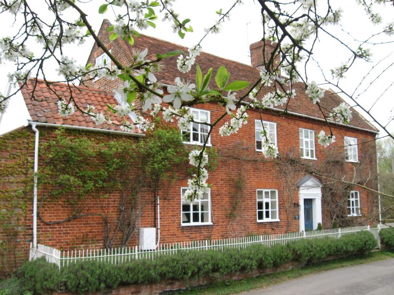
TM 36 SE STERNFIELD SANDY LANE
2/126 Brook Famhouse
-
- II
Farmhouse. C18. Red brick, plaintiled roof. 2 storeys and attic. 4 window
range, 3-light casements, flat brick arches; asymmetrical doorway: plain
pilasters, frieze, pediment, inset 6-panel door, the upper 4 panels glazed.
Brick eaves modillion cornice. Brick and pantile extension to left hand side.
Listing NGR: TM3870461051
External links are from the relevant listing authority and, where applicable, Wikidata. Wikidata IDs may be related buildings as well as this specific building. If you want to add or update a link, you will need to do so by editing the Wikidata entry.


Other nearby listed buildings