Latitude: 53.6555 / 53°39'19"N
Longitude: -1.7522 / 1°45'7"W
OS Eastings: 416476
OS Northings: 417694
OS Grid: SE164176
Mapcode National: GBR JV65.GB
Mapcode Global: WHCB2.1CXZ
Plus Code: 9C5WM64X+54
Entry Name: Nether Hall Barn
Listing Date: 18 July 1975
Grade: II
Source: Historic England
Source ID: 1231771
English Heritage Legacy ID: 406995
ID on this website: 101231771
Location: Rawthorpe, Kirklees, West Yorkshire, HD5
County: Kirklees
Electoral Ward/Division: Dalton
Parish: Non Civil Parish
Built-Up Area: Huddersfield
Traditional County: Yorkshire
Lieutenancy Area (Ceremonial County): West Yorkshire
Church of England Parish: Rawthorpe St James
Church of England Diocese: Leeds
RAWTHORPE LANE
1.
5113
Rawthorpe
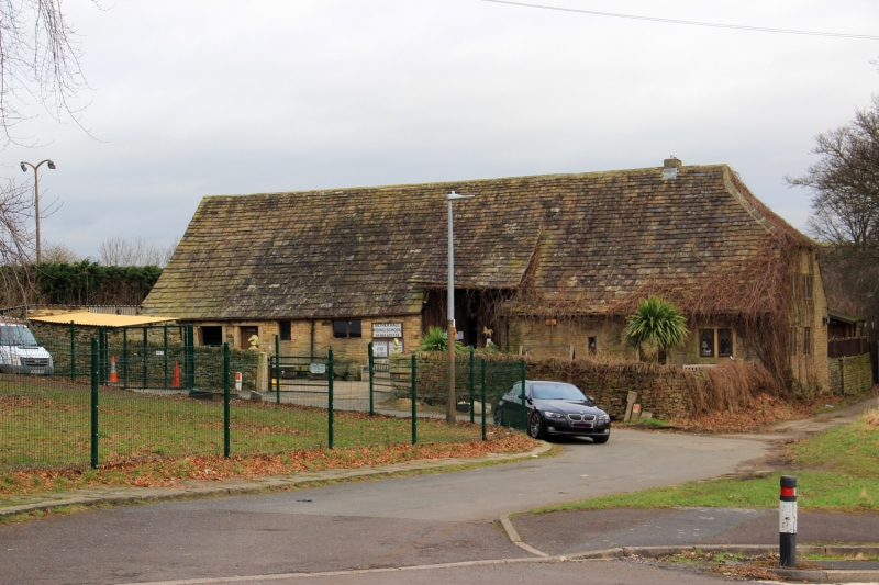
Nether Hall Barn
SE 1617 29/1137 18.7.75.
II
2.
C18 or older. Hammer dressed stone. Pitched stone slate roof, half-hipped
at south end. Aisled timber construction with arch braces and wind braces
to arcade plates. Planked double doors in barn porch on west side. Various
3 and 2-light stone mullioned windows.
Listing NGR: SE1647617694
External links are from the relevant listing authority and, where applicable, Wikidata. Wikidata IDs may be related buildings as well as this specific building. If you want to add or update a link, you will need to do so by editing the Wikidata entry.


Other nearby listed buildings