Latitude: 52.4867 / 52°29'12"N
Longitude: -2.2294 / 2°13'45"W
OS Eastings: 384517
OS Northings: 287664
OS Grid: SO845876
Mapcode National: GBR 1BN.15Y
Mapcode Global: VH918.9RRL
Plus Code: 9C4VFQPC+M6
Entry Name: Old Windmill
Listing Date: 18 December 1987
Grade: II
Source: Historic England
Source ID: 1231839
English Heritage Legacy ID: 407083
ID on this website: 101231839
Location: South Staffordshire, DY7
County: Staffordshire
District: South Staffordshire
Civil Parish: Kinver
Traditional County: Staffordshire
Lieutenancy Area (Ceremonial County): Staffordshire
Church of England Parish: Kinver St Peter
Church of England Diocese: Lichfield
Tagged with: Windmill
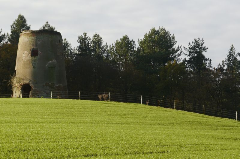
KINVER C.P. MILL LANE (South side)
SO 88 NW
8/97 Old Windmill
GV II
Windmill base. C18. Red brick, partly rendered. 3 storeys with
timber wall plate surmounted by fragments of machinery. Doors to east
and west; square window openings. Interior gutted and roof gone.
Listing NGR: SO8451787664
External links are from the relevant listing authority and, where applicable, Wikidata. Wikidata IDs may be related buildings as well as this specific building. If you want to add or update a link, you will need to do so by editing the Wikidata entry.


Other nearby listed buildings