Approximate Location Map
Large Map »
Latitude: 52.9479 / 52°56'52"N
Longitude: -1.854 / 1°51'14"W
OS Eastings: 409908
OS Northings: 338959
OS Grid: SK099389
Mapcode National: GBR 386.0EH
Mapcode Global: WHCFH.H5CD
Plus Code: 9C4WW4XW+5C
Entry Name: Banks Farmhouse
Listing Date: 12 January 1966
Grade: II*
Source: Historic England
Source ID: 1231926
English Heritage Legacy ID: 407201
ID on this website: 101231926
Location: Stubwood, East Staffordshire, ST14
County: Staffordshire
District: East Staffordshire
Civil Parish: Rocester
Traditional County: Staffordshire
Lieutenancy Area (Ceremonial County): Staffordshire
Church of England Parish: Rocester St Michael
Church of England Diocese: Lichfield
Tagged with: Farmhouse
SK 03 NE ROCESTER C.P. ROCESTER
8/171 Banks Farmhouse
12/1/66 II*
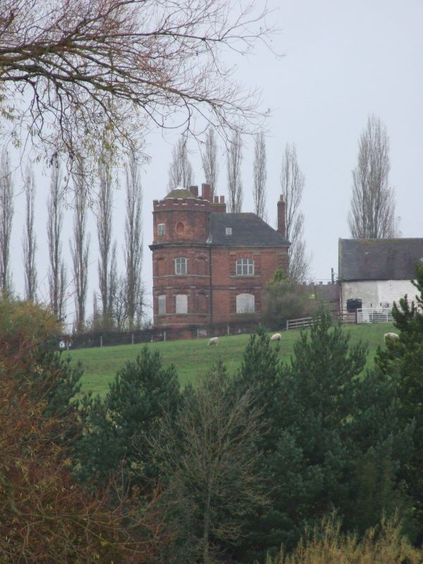
Farmhouse. Early C18. Red brick; hipped clay tile roof; brick
integral end stack and ridge stack. L-shape plan with 5 sides of
an octagonal tower projecting from the outer corner to the south;
Provincial Baroque with early castellated detail and mannered brick-
work. SW elevation: 2 storeys on high basement, pilaster strip to
left with stone insets as caps to each floor, 3-storey crenellated tower
also on basement, first floor band and boldly moulded eaves cornice
continued and broken around tower; 2 bays, the right hand one being
the tower with windows to each face, mostly blind, segmental headed
casements with panelled aprons, the left hand windows have mannered
rustication and surrounds and are in a slight break which extends to
the eaves cornice; this is emphasized by the use of stone 'caps'
above each window jamb forming an effective rusticated pilaster
strip, the windows of the tower are not so side and are distinguished by
sill band to each floor, simply moulded architraves and boldly
projecting triple keystones; blocked oval oculus to second floor
centre of tower; tower has basement door to left. Interior: Open
well staircase with turned balusters; 2 fireplaces in tower with
raised keys; 2 pairs of upper crucks, one pair elbowed. Situated on
the edge of a hill overlooking the Dove Valley. B.O.E. P.226.
Listing NGR: SK0990838959
External links are from the relevant listing authority and, where applicable, Wikidata. Wikidata IDs may be related buildings as well as this specific building. If you want to add or update a link, you will need to do so by editing the Wikidata entry.


Other nearby listed buildings
