Approximate Location Map
Large Map »
Latitude: 53.6474 / 53°38'50"N
Longitude: -1.7848 / 1°47'5"W
OS Eastings: 414323
OS Northings: 416790
OS Grid: SE143167
Mapcode National: GBR HVZ8.D7
Mapcode Global: WHCB1.KL95
Plus Code: 9C5WJ6W8+X3
Entry Name: 12-20, St Georges Square
Listing Date: 11 February 1977
Grade: II*
Source: Historic England
Source ID: 1232139
English Heritage Legacy ID: 407018
ID on this website: 101232139
Location: Newtown, Kirklees, West Yorkshire, HD1
County: Kirklees
Electoral Ward/Division: Newsome
Parish: Non Civil Parish
Built-Up Area: Huddersfield
Traditional County: Yorkshire
Lieutenancy Area (Ceremonial County): West Yorkshire
Church of England Parish: Huddersfield St Peter
Church of England Diocese: Leeds
Tagged with: Building
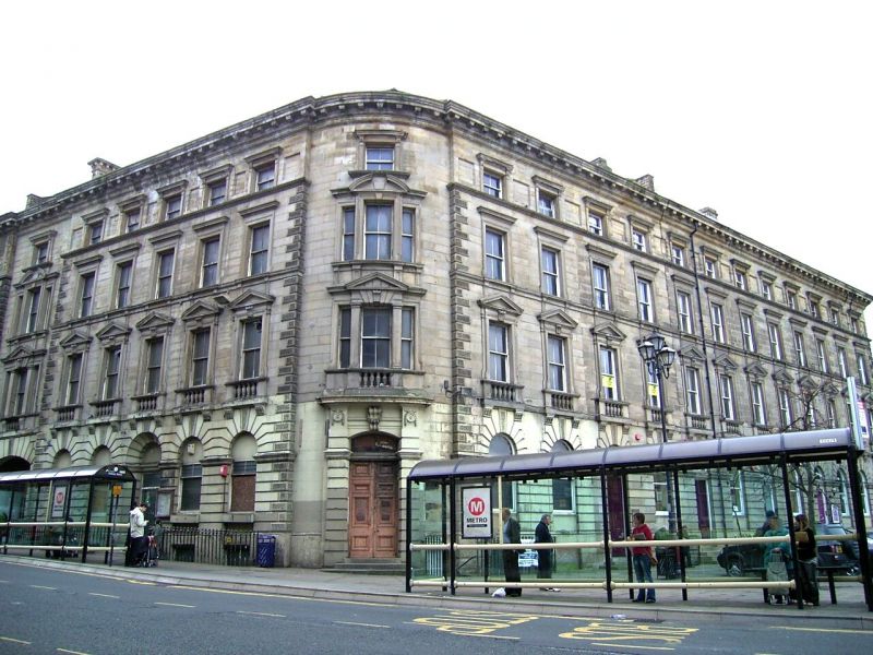
ST GEORGE'S SQUARE
1.
5113
(South Side)
Nos 12 to 20 (even)
SE 1416 NW 1/43A 11.2.77.
II* GV
2.
Mid C19. A single composition with Nos 8 and 10 Railway Street, which is,
in toto, as follows.
Ashlar. Hipped slate roof. 4 storeys and basement. Deeply moulded modillion
eaves cornice. Continuous moulded sill bands to 2nd and 3rd floors. Plain
band above ground floor. Continuous moulded impost band to ground floor windows,
below which ground floor is horizontally rusticated. Moulded plinth. Vermiculated
and rusticated quoins. 12 ranges of sashes. Ground floor windows round-arched
with vermiculated keystones. 1st floor windows have moulded surrounds, gadrooned
keystones, frames with pulvinated friezes and triangular pediments, and balustrades
on consoles with vase-shaped balusters. Above pediments 2 triglyph-like consoles
link them to the cills of the 2nd floor windows: these have moulded surrounds
and cornices. 3rd floor windows are separated by sunk and moulded panels,
have plain pilasters and brackets to cornices. Cast iron railings to areas,
with baluster finials. St George's Street elevation is a simplified version
of the former, with 12 window ranges, one of which is blind.
Listing NGR: SE1432316790
External links are from the relevant listing authority and, where applicable, Wikidata. Wikidata IDs may be related buildings as well as this specific building. If you want to add or update a link, you will need to do so by editing the Wikidata entry.


Other nearby listed buildings
