Approximate Location Map
Large Map »
Latitude: 51.1402 / 51°8'24"N
Longitude: 0.9562 / 0°57'22"E
OS Eastings: 606891
OS Northings: 142041
OS Grid: TR068420
Mapcode National: GBR SYB.GKW
Mapcode Global: VHKKP.JLCR
Plus Code: 9F324XR4+3F
Entry Name: Burches Farmhouse
Listing Date: 16 February 1989
Grade: II
Source: Historic England
Source ID: 1232926
English Heritage Legacy ID: 408310
ID on this website: 101232926
Location: Ashford, Kent, TN25
County: Kent
District: Ashford
Civil Parish: Brabourne
Traditional County: Kent
Lieutenancy Area (Ceremonial County): Kent
Tagged with: Farmhouse
TR 04 SE BRABOURNE WEST BRABOURNE
4/45 Burche's
Farmhouse
II
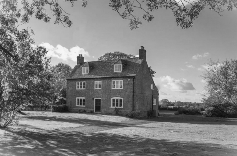
House. Mid C18. Red and blue chequered brick with plain tiled roof.
Two storeys and attics on plinth with dogtooth cornice to roof with
stacks to end left and to end right. Two hipped dormers. Regular
fenestration of 3 wooden casements on first floor and 2 on ground floor
with segmental heads. Central half-glazed door. Catslide outshot to
rear.
Listing NGR: TR0689142041
External links are from the relevant listing authority and, where applicable, Wikidata. Wikidata IDs may be related buildings as well as this specific building. If you want to add or update a link, you will need to do so by editing the Wikidata entry.


Other nearby listed buildings
