Approximate Location Map
Large Map »
Latitude: 50.849 / 50°50'56"N
Longitude: -1.1655 / 1°9'55"W
OS Eastings: 458843
OS Northings: 105827
OS Grid: SU588058
Mapcode National: GBR 9B3.L50
Mapcode Global: FRA 86FV.KRZ
Plus Code: 9C2WRRXM+HQ
Entry Name: Cartshed with Loft over and Attached Farmyard Wall with Outbuildings at Home Farm at Cams Hall
Listing Date: 20 December 1989
Grade: II
Source: Historic England
Source ID: 1233919
English Heritage Legacy ID: 409516
ID on this website: 101233919
Location: Downend, Fareham, Hampshire, PO16
County: Hampshire
District: Fareham
Electoral Ward/Division: Portchester West
Parish: Non Civil Parish
Traditional County: Hampshire
Lieutenancy Area (Ceremonial County): Hampshire
Church of England Parish: Fareham St Peter and St Paul
Church of England Diocese: Portsmouth
Tagged with: Carriage house
SU 50 NE FAREHAM PORTCHESTER ROAD
(south side, off)
21/316 Cartshed with loft over
and attached farmyard
wall with outbuildings at
Home Farm at Cams Hall
GV II
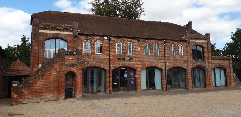
Cartshed with loft over and attached farmyard walls and outbuildings. Mid-late
C19 (cartshed dated 'HPD 1872'). Cartshed of red brick with blue headers in
English bond with plain tile roof; yard wall of red brick in Flemish garden wall
bond with cream Beaulieu brick gatepier; outbuilding attached to wall of coursed
stone and red brick with collapsed Welsh slate roof. Cartshed: 2 storeys, 6
bays with lean-to on right side and small outbuilding projecting to rear left.
Bays arranged near-symmetrically 1:4:1 having, on ground floor, round-cornered
piers supporting segmental arches; left bay has external stair, with round-
cornered piers, and dentilled band and cornice over archway on right. On first
floor outer bays have wide segmental-arched openings as ground floor, and
between them paired, round-arched small-paned metal windows; central datestone.
Outer bays have piers rising up to flank dentilled parapets. Half-hipped roof,
collapsed over left end. Lean-to on right side fronted by archway and dentilled
parapet as before, with stair on right leading up to first floor; much of the
lean-to collapsed; its right return has 2 reused stone brackets. Rear: earlier
plinth; first floor windows as before. Outbuilding projecting on right has
raking buttresses, board door with hatch over, and hipped roof. Interior: brick
columns support cross-beams; star-braced roof trusses and raking queen struts.
Attached to right side of cartshed is yard wall which is approximately 3 metres
high with semi-circular brick coping; it curves around and at right end ramps
down to gatepier with stone cap. Attached to it is gabled outbuilding which was
pointed-arched window, and a doorway in left return. Derelict at time of
inspection (October 1989).
Listing NGR: SU5799407358
External links are from the relevant listing authority and, where applicable, Wikidata. Wikidata IDs may be related buildings as well as this specific building. If you want to add or update a link, you will need to do so by editing the Wikidata entry.


Other nearby listed buildings
