Approximate Location Map
Large Map »
Latitude: 51.5575 / 51°33'27"N
Longitude: -0.0829 / 0°4'58"W
OS Eastings: 532996
OS Northings: 186035
OS Grid: TQ329860
Mapcode National: GBR HC.FRY
Mapcode Global: VHGQT.J30T
Plus Code: 9C3XHW58+2R
Entry Name: 143 and 145, Albion Road N16
Listing Date: 23 July 1987
Grade: II
Source: Historic England
Source ID: 1235677
English Heritage Legacy ID: 426328
ID on this website: 101235677
Location: Stoke Newington, Hackney, London, N16
County: London
District: Hackney
Electoral Ward/Division: Clissold
Parish: Non Civil Parish
Built-Up Area: Hackney
Traditional County: Middlesex
Lieutenancy Area (Ceremonial County): Greater London
Church of England Parish: St Mary Stoke Newington
Church of England Diocese: London
Tagged with: Building
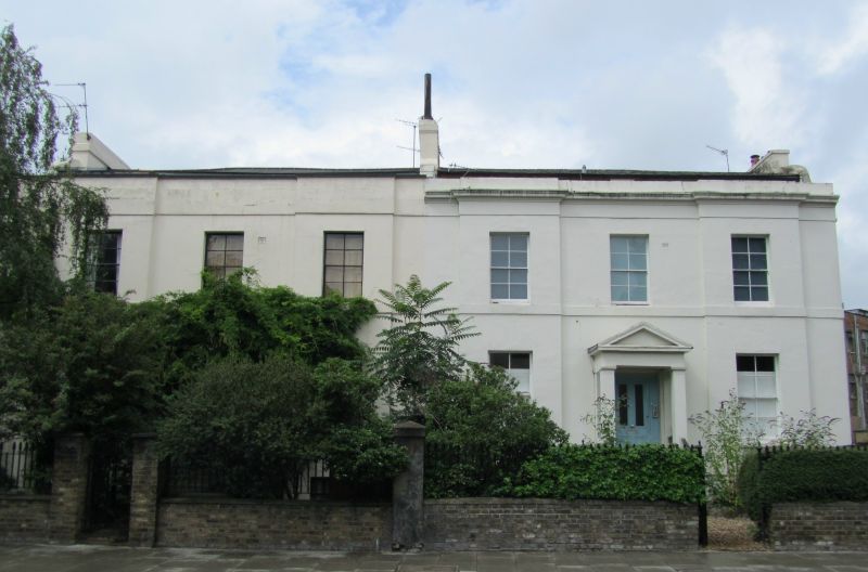
ALBION ROAD N16
1.
5013
TQ 3386 12/3002 Nos 143 and 145
II GV
2.
Pair of houses. Circa 1840. Stucco. Slated low pitched roof to No 145; concrete tiled
low pitched roof to no 143. 2 storeys plus basement. Each house 3 windows wide
with central entrance in projecting pedimented porch with square piers and half
glazed four-panelled door. Outer bays project slightly. Square headed windows, 8
paned sashes with glazing bars. Stucco bands between storeys. Cornice to No 145;
cornice removed to No 143. Dormer windows recessed behind parapet. Shaped gable end
to No 145.
Listing NGR: TQ3299686035
External links are from the relevant listing authority and, where applicable, Wikidata. Wikidata IDs may be related buildings as well as this specific building. If you want to add or update a link, you will need to do so by editing the Wikidata entry.


Other nearby listed buildings
