Latitude: 51.5151 / 51°30'54"N
Longitude: -0.1722 / 0°10'19"W
OS Eastings: 526928
OS Northings: 181160
OS Grid: TQ269811
Mapcode National: GBR 5C.J1
Mapcode Global: VHGQY.Y5VV
Plus Code: 9C3XGR8H+24
Entry Name: 107-121, SUSSEX GARDENS W2 (See details for further address information)
Listing Date: 5 February 1970
Grade: II
Source: Historic England
Source ID: 1237436
English Heritage Legacy ID: 428696
ID on this website: 101237436
Location: Paddington, Westminster, London, W2
County: London
District: City of Westminster
Electoral Ward/Division: Hyde Park
Parish: Non Civil Parish
Built-Up Area: City of Westminster
Traditional County: Middlesex
Lieutenancy Area (Ceremonial County): Greater London
Church of England Parish: St John Evan Hyde Park Crescent
Church of England Diocese: London
Tagged with: Building
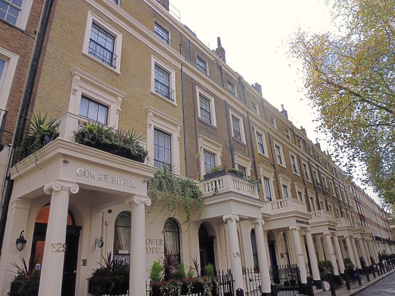
TQ 2681 SE CITY OF WESTMINSTER SUSSEX GARDENS, W2
52/17 (south-east side)
5.2.70 Nos 107 to 121 (odd) and
Nos 129 to 161 (odd)
GV II
Terrace. Early-mid C19. Brown brick in Flemish bond, part reddened. Stucco
ground floor, mainly channelled, and stucco dressings. 4 storeys and basement.
Balanced composition of 14-bay 'central' breakforward with 16-bay wing to right
and 13 bays to left (a further 8 bays flanking the centre on the left have been
replaced by C20 building). 4-bay breakforward to each end.
14-bay centre has projecting Ionic porches and round-arched sashes with margin
lights. Outer bays have pilastered entrances with overlights and sashes. First
floor: to centre, stucco balustrade, to wings, iron balconies. Sashes, some
with glazing bars, in architraves. Cornice at 3rd floor level. 4-bay return to
Radnor Place. Iron basement railings. Sussex Gardens, known originally as Grand
Junction Road, formed an important feature of the original layout of Bayswater.
The London Encyclopedia,C Hibbert and B Weinreb (eds), 1983, p.46 and 848.
Listing NGR: TQ2692881160
External links are from the relevant listing authority and, where applicable, Wikidata. Wikidata IDs may be related buildings as well as this specific building. If you want to add or update a link, you will need to do so by editing the Wikidata entry.


Other nearby listed buildings