Approximate Location Map
Large Map »
Latitude: 51.6263 / 51°37'34"N
Longitude: -2.3681 / 2°22'5"W
OS Eastings: 374613
OS Northings: 192011
OS Grid: ST746920
Mapcode National: GBR 0MD.VHD
Mapcode Global: VH95F.WDX3
Plus Code: 9C3VJJGJ+GP
Entry Name: Boundary House, Including Gatepiers and Wall
Listing Date: 23 June 1952
Last Amended: 9 September 1985
Grade: II
Source: Historic England
Source ID: 1238074
English Heritage Legacy ID: 415366
ID on this website: 101238074
Location: Kingswood, Stroud, Gloucestershire, GL12
County: Gloucestershire
District: Stroud
Civil Parish: Kingswood
Built-Up Area: Kingswood
Traditional County: Gloucestershire
Lieutenancy Area (Ceremonial County): Gloucestershire
Church of England Parish: Kingswood St Mary the Virgin
Church of England Diocese: Gloucester
Tagged with: Architectural structure
ST 79 SW KINGSWOOD CHARFIELD ROAD
(south side)
7/260 Boundary House (formerly listed
as Rectory, Kingswood), including
23.6.52 gatepiers and wall
GV II
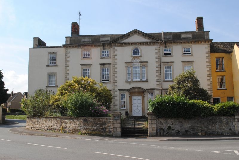
Former rectory now large private house. Mid C18. Rendered, stone
alternating chamfered quoins and moulded stone modillion cornice,
hipped Cotswold stone slate roof with tall parapet with 4 stone
panels and central dentil pediment, brick end stacks. Long range
with central projecting rear bay forming shallow T-shape, and
additional single bay wing to left. 3 storeys and basement. Main
symmetrical range of 5 bays, 2/1/2 with wide centre bay projecting
forward beneath pediment and with additional quoins. 12-pane
sashes with moulded stone architraves and dentil cornice to first
and ground floors. Centre bay has Venetian window on first floor
also with moulded stone architraves and dentil cornice, and with 4
Ionic pilasters and round-headed section blocked but with
decorative Gothick tracery. Ground floor has central doorcase up 3
large semi-circular stone steps, with 8-pane side lights as other
windows and central door with large moulded stone segmental
pediment on consoles, moulded stone frame and 6 rectangular fielded
panels and lower section in fielded X-shape. Attic storey has
small 6-pane sashes with moulded stone architraves linked directly
to cornice, central window round-headed with radial top sash.
Basement windows below stone offset, with plain round-headed stone
architraves and keys-tone (windows not visible). Wing to left has
12-pane sash with plain stone architrave to each floor. Projecting
rear wing has Venetian window on first floor also.
Interior not accessible but likely to be of interest. Gatepiers in
dressed stone with rusticated square piers, moulded modillion
cornice and figure of dog's head on double stepped base, about 2m
total height. Possible original polygonal finials (matching those
on Chestnut Park Farmhouse adjoining, q.v.) lie at the top of stone
steps behind the piers. No gates remaining. Wall adjoining on
each side in coped rubblestone (random coursed to left) curving
back on left for about 16m to join house, and running about 7m to
right to join gatepiers of Chestnutpark Farmhouse. About 1.40m in
height.
Listing NGR: ST7461392011
External links are from the relevant listing authority and, where applicable, Wikidata. Wikidata IDs may be related buildings as well as this specific building. If you want to add or update a link, you will need to do so by editing the Wikidata entry.


Other nearby listed buildings
