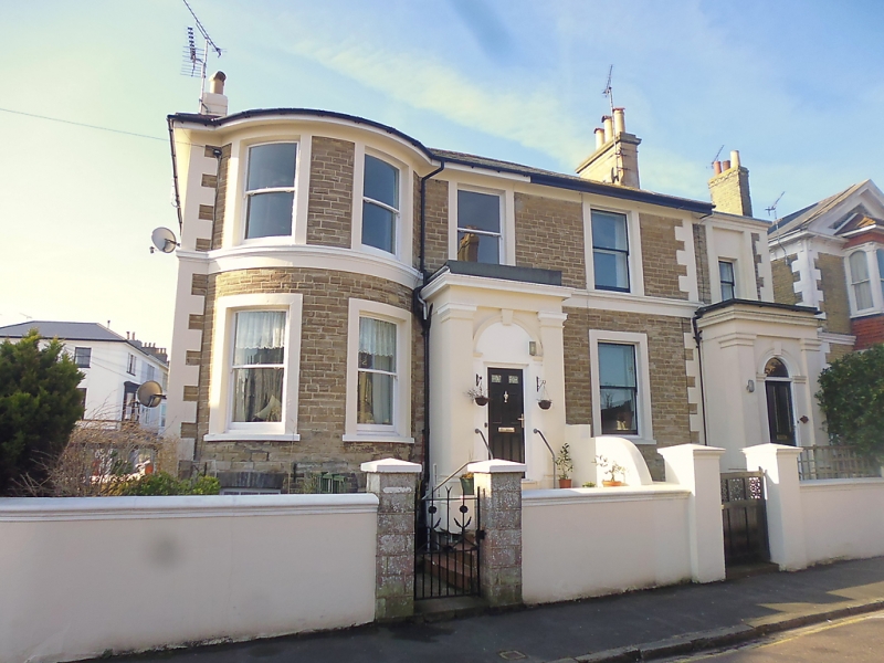
Latitude: 50.7305 / 50°43'49"N
Longitude: -1.1541 / 1°9'14"W
OS Eastings: 459794
OS Northings: 92666
OS Grid: SZ597926
Mapcode National: GBR 9CN.31R
Mapcode Global: FRA 87G4.XWH
Plus Code: 9C2WPRJW+68
Entry Name: 50 and 50A, the Strand
Listing Date: 18 May 1972
Grade: II
Source: Historic England
Source ID: 1238762
English Heritage Legacy ID: 416391
ID on this website: 101238762
Location: St John's Park, Isle of Wight, PO33
County: Isle of Wight
Civil Parish: Ryde
Built-Up Area: Ryde
Traditional County: Hampshire
Lieutenancy Area (Ceremonial County): Isle of Wight
Church of England Parish: Oakfield St John
Church of England Diocese: Portsmouth
Tagged with: Building
THE STRAND 1. 1577 (South Side) Nos 50 & 50A SZ 5992 3/340
II GV
2. Circa 1840/50 villa. Divided at an early date into two houses. Two storeys and basement faced with stone cut in imitation of bricks, rendered quoins. Frieze, first floor moulded sill course with frieze below, plinth. Low pitched hipped slate roof with wide eaves. Four windows two in bow through both storeys, recessed, sash, no glazing bars, block sills to ground floor. Panelled door semi-circular fanlight paired pilasters flanking keystone breaking up into frieze cornice projecting from sill course. Flight of nine steps, rendered parapets copings and capped piers porch to West of bow and, identical one in two storeyed extension of window to West, also faced in stone cut in imitation of bricks. Porches are enclosed and have Doric pilasters at angles, entablature over. Recessed panelled doors with semi-circular fanlights flanked by pilaster with moulded arches, keystones over.
Nos 46 to 50A (consec) form a group.
Listing NGR: SZ5979492666
External links are from the relevant listing authority and, where applicable, Wikidata. Wikidata IDs may be related buildings as well as this specific building. If you want to add or update a link, you will need to do so by editing the Wikidata entry.


Other nearby listed buildings