Latitude: 52.6392 / 52°38'20"N
Longitude: -2.284 / 2°17'2"W
OS Eastings: 380876
OS Northings: 304638
OS Grid: SJ808046
Mapcode National: GBR 079.KCR
Mapcode Global: WH9DC.WXKM
Plus Code: 9C4VJPQ8+M9
Entry Name: Churchyard Cross About 10 Metres South of the Tower of the Church of St Cuthbert
Listing Date: 26 September 1984
Grade: II*
Source: Historic England
Source ID: 1239196
English Heritage Legacy ID: 416984
ID on this website: 101239196
Location: St Cuthbert's Church, Albrighton, Shropshire, WV7
County: Shropshire
Civil Parish: Donington
Traditional County: Shropshire
Lieutenancy Area (Ceremonial County): Shropshire
Church of England Parish: Donington St Cuthbert
Church of England Diocese: Lichfield
Tagged with: Churchyard cross
DONINGTON C.P. RECTORY ROAD
SJ 80 SW
(east side)
6/76
Churchyard cross about 10m
south of the tower of the
G.V. Church of St. Cuthbert
II*
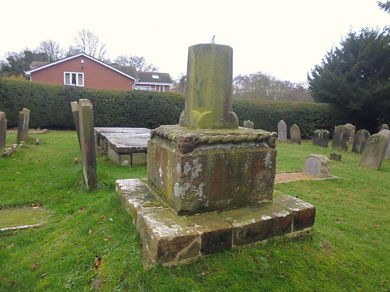
Churchyard cross, now sundial. Medieval, probably C14 or C15. Sandstone.
Square socket stone on a probably later stone plinth, fragment of shaft
approximately 0.8m high. The upper edge of the socket stone has cable
moulding and grotesque faces to the corners; the shaft has a square
base and is broached to give an octagonal section; it now forms the
base for a sundial. The cable moulding and the faces on the corners
of the shaft are very similar to those on the cross at the neighbouring
Church of St. Mary Magdalene, Albrighton (q.v. under Albrighton C.P.).
Listing NGR: SJ8087604638
External links are from the relevant listing authority and, where applicable, Wikidata. Wikidata IDs may be related buildings as well as this specific building. If you want to add or update a link, you will need to do so by editing the Wikidata entry.


Other nearby listed buildings